 Atlas of China
Qianxinan 黔西南Qiánxīnán
A plain of 20,000 karst cones, a split-earth gorge and 24 hairpin bends
- Type
- Bouyei and Miao Autonomous Prefecture
- Region
- Guizhou
- Seat
- Xingyi
- Listed sites
- 171 rated 5A · 14 rated 4A · 4 national heritage
About Qianxinan
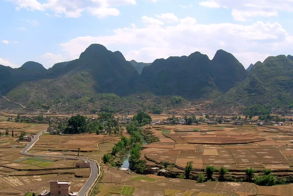
Qianxinan, home to many Buyei and Miao people, is cone-karst country. Around Xingyi the Wanfenglin plain holds more than 20,000 limestone peaks and the Maling River Canyon cuts a deep cleft just outside town, both within the Xingyi UNESCO Global Geopark, designated in 2024. In Qinglong the 24-Switchback Road climbs a hillside in 24 hairpins, a wartime supply route reworked by US army engineers in 1943.
Listed sites in Qianxinan
17 sites in Qianxinan are on the official lists. Those with a page of their own link to it; the rest open as cards on the map.
- Wanfenglin Peak Forest 万峰林 5A scenic area
Wanfenglin is a plain of cone-shaped karst peaks south of Xingyi; UNESCO's geopark profile counts more than 20,000 of them. - 24-Switchback Road 二十四道拐 4A scenic area · National heritage site
A winding mountain road built in 1936 on the old Guizhou–Yunnan highway, climbing about 250 m in 24 hairpin bends over four kilometres. - Amei Qituo Town 阿妹戚托小镇 4A scenic area · on the map
A hillside town built to rehouse the whole of Sanbao Yi township on the edge of Qinglong county town, named after Amei Qituo, a Yi bridal dance on China's national intangible cultural heritage list that is often called the Eastern tap dance. - Beipan River Canyon, Zhenfeng 北盘江大峡谷 4A scenic area · on the map
A U-shaped canyon of the Beipan River in Zhenfeng, about 94 km long within the county, with karst peaks, caves and waterfalls along a reservoir created by the Dongqing dam; the area is part of the Beipan River National Wetland Park. - Fangmaping Grassland 放马坪 4A scenic area · on the map
A highland grassland of about 21,000 mu at an average height of 1,630 m on the northern edge of Xingren, nicknamed Gaoyuan Saiwai, the plateau frontier. - Guizhou Chun Leisure Park 贵州醇景区 4A scenic area · on the map
A leisure park of about 2,400 mu in the urban area of Xingyi, named after the Guizhou Chun baijiu brand and described in provincial tourism promotion as one of 14 liquor-and-tourism scenic areas in Guizhou. - Lutun Archways and Old Town 鲁屯牌坊群 4A scenic area · National heritage site · on the map
Lutun is a Ming-era military settlement in the Yilong New Area east of Xingyi, where three Qing stone memorial archways dated 1839 to 1846 still stand in the old streets, two honouring people who reached 100 and one a woman praised for chastity and filial devotion; the group is a national-level protected monument. - Maling River Canyon 马岭河峡谷 4A scenic area · on the map
A fissure gorge cut by the Maling River just north-east of Xingyi, more than 70 km long and up to a few hundred metres deep, with waterfalls pouring from its walls and lime-rich deposits hanging from the cliffs. - Pu'an Tea Culture Scenic Area 普安茶文化生态旅游景区 4A scenic area · on the map
A tea-tourism area at Chayuan, east of Pu'an town, built around local claims that the region is an origin of tea: the county dates a fossilised tea seed found nearby in 1980 to more than two million years ago, and says more than 20,000 ancient wild tea trees survive in Pu'an. - Sanchahe Lake, Zhenfeng 三岔河 4A scenic area · on the map
A reservoir lake in Zhexiang town, north of Zhenfeng, named for the three rivers that meet here and developed as a lakeside leisure area of roughly 2,100 mu. - Shuangyufeng Twin Peaks 双玉峰 4A scenic area · on the map
Two rounded karst peaks rising about 260 m above their surroundings, which the local Buyei call the Holy Mother Peaks, on the road from Zhenfeng towards Guiyang; many local pages still use the older name Shuangrufeng. - Wanfeng Lake 万峰湖 4A scenic area · on the map
A large reservoir on the Nanpan River where Guizhou, Yunnan and Guangxi meet, formed by the Tianshengqiao-I dam and named for the many karst peaks around it. - Xingyi Geopark Museum 兴义国家地质公园博物馆 4A scenic area · on the map
A geopark museum in Wusha, west of Xingyi, devoted to the Middle Triassic marine reptiles and fishes of the Xingyi fauna, above all the small reptile Keichousaurus, known as the Guizhou dragon. - Zhaoti Embankment and Lotus Wetland 招堤 4A scenic area · on the map
A lotus-filled wetland on the north-eastern edge of the old town of Anlong, built around a stone embankment, a provincial-level protected monument, that a local garrison officer raised in 1694 to hold back floodwater. - Zhenfeng Ancient Town 贞丰古城 4A scenic area · on the map
A restored old quarter at the foot of Feng Hill on the east side of Zhenfeng, once the Buyei market settlement of Mingu, with Ming and Qing streets, courtyard houses, the Wenchang Palace and the former guild halls of merchants from Hunan, Hubei, Guangdong and Guangxi. - Liu Family Manor, Xingyi 兴义刘氏庄园 National heritage site · on the map
A walled family compound of about 13 courtyard houses on roughly 70 mu at Xiawutun, added to over four generations of the Liu family in a mix of Chinese and Western styles. - Tomb of the Eighteen Scholars, Anlong 明十八先生墓 National heritage site · on the map
The tombs and memorial shrine of eighteen Southern Ming court officials killed in 1654, after they objected to the domination of the court at Anlong by Sun Kewang, leader of the Daxi army.
On the map
Open Qianxinan on the illustrated map to see its outline, its places and listed sites together, and to add them to a trip.
Open Qianxinan on the map