 Atlas of China
Shangqiu 商丘Shāngqiū
A town set in a ring of water, Han royal tombs and the name of the Song
About Shangqiu
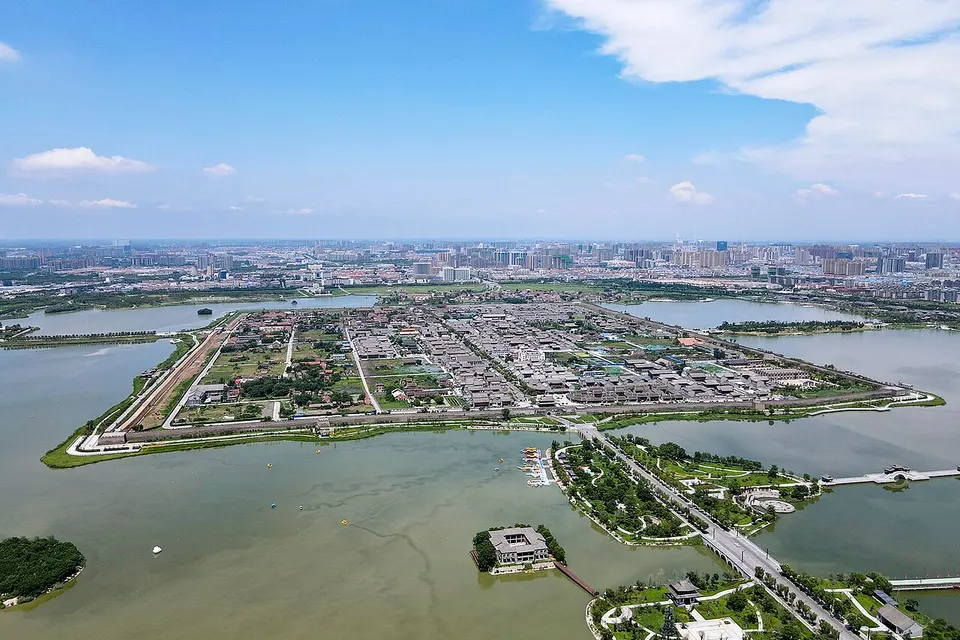
Shangqiu, now a rail junction, gave the Song dynasty its name: Zhao Kuangyin was military governor of Song prefecture here before founding it. The walled Ming and Qing town of Guide, square within a round ring of water, sits over the remains of older cities, beside the site of Yingtian Academy, one of the four great academies of the Northern Song. At Mangdang Mountain in Yongcheng, Han kings of Liang were buried; their tombs yielded a jade suit sewn with gold.
Listed sites in Shangqiu
14 sites in Shangqiu are on the official lists. Those with a page of their own link to it; the rest open as cards on the map.
- Mount Mangdang 芒砀山 5A scenic area · National heritage site
A cluster of low hills in northern Yongcheng, rising to 156.8 m, where Liu Bang, the future founder of the Han dynasty, began his revolt against the Qin by slaying a white serpent, and where the Western Han kings of Liang cut their tombs deep into the rock. - Fengqi Lake, Sui County 凤栖湖 4A scenic area · on the map
A lakeside park in Sui county town created from 2018 on the site of a disused brickworks. - Huaihai Campaign Chenguanzhuang Memorial 淮海战役陈官庄纪念馆 4A scenic area · on the map
A memorial park of about 13 ha at Chenguanzhuang, where the Chenguanzhuang encirclement battle of the Huaihai Campaign, in the Chinese Civil War of 1948–49, was fought. - Longgang Bay Scenic Area 龙港湾 4A scenic area · on the map
A farm-tourism and study-tour park at Yinzhuang village, Taiping town, Xiayi County, whose rated scenic area covers about 55 ha of a 340 ha agricultural base. - North Lake, Sui County 睢县北湖 4A scenic area · on the map
A lake of about 3.3 km² on the north side of Sui county town, formed when the old walled city of Suizhou was drowned after the Yellow River dykes were breached in 1642. - Riyue Lake, Shangqiu 日月湖 4A scenic area · on the map
An artificial lake of about 1 km² in the business district of Shangqiu's new town, dug as part of the new district's water system to store Yellow River water for irrigation and as a landscaped park. - Riyue Lake, Yongcheng 永城日月湖 4A scenic area · on the map
A large park created from 2009 on land that had subsided over coal workings between Yongcheng's old and new towns, planned to cover 24 km², about a quarter of it water. - Shangqiu Ancient City 商丘古城 4A scenic area · National heritage site
The walled city of Guide prefecture, built in 1511 after floods destroyed the earlier town, whose brick inner wall (about 4.4 km round), broad moat-lake and outer earthen rampart give it the 'round outside, square inside' plan of a Chinese coin. - Shangqiu Museum 商丘博物馆 4A scenic area · on the map
Shangqiu's city museum, which opened in a new building on Huashang Avenue in 2016 and holds about 19,000 objects, mostly from excavations in the region. - Wanggongzhuang Painting Village 王公庄 4A scenic area · on the map
A village about 25 km north-east of Minquan county town known as China's first tiger-painting village, where more than 900 villagers work in painting, mostly tigers in the traditional Chinese style. - Chongfa Temple Pagoda 崇法寺塔 National heritage site · on the map
An octagonal nine-storey brick pagoda 34.6 m tall, built in 1093–1098 under the Northern Song, standing in the martyrs' cemetery in the north-east corner of Yongcheng's old town; the temple itself has gone. - Former Headquarters of the Huaihai Campaign General Front Committee 商丘淮海战役总前委旧址 National heritage site · on the map
The site at Zhangcaiyuan village, 12 km south-east of Shangqiu's old city, that from 30 December 1948 to 24 March 1949 housed in turn the General Front Committee of the Huaihai Campaign, the Central Plains Field Army headquarters and the front committee for the Yangtze River crossing. - Shengshou Temple Pagoda, Yanzhuang 阎庄圣寿寺塔 National heritage site · on the map
A six-sided, nine-storey brick pagoda of the dense-eave type, roughly 20 m tall, built under the Northern Song for the Shengshou Temple, which no longer exists, at Yanzhuang village. - Zhecheng Ancient City Site 柘城故城 National heritage site · on the map
The site of Zhecheng's county town from the Warring States period to the Ming, abandoned in the 16th century when Yellow River silt built up outside its walls and left the interior lower than the land around, so that it became a lake.
On the map
Open Shangqiu on the illustrated map to see its outline, its places and listed sites together, and to add them to a trip.
Open Shangqiu on the map