 Atlas of China
Xinyang 信阳Xìnyáng
Maojian green tea, old missionary villas on Mount Jigong and a rice-eating south
About Xinyang
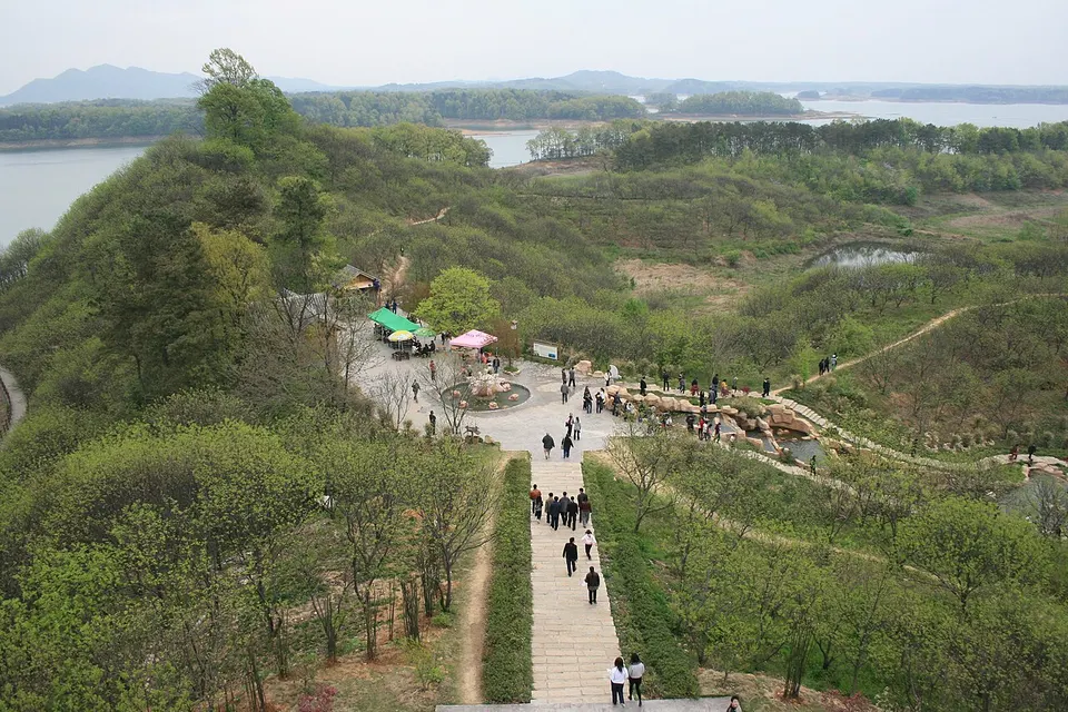
Xinyang lies between the Huai River and the Tongbai and Dabie mountains on the Hubei border, and, unusually for Henan, eats rice rather than wheat as its staple. The hills in the south-west grow Xinyang Maojian, counted among China's ten famous teas. Mount Jigong, named for its rooster-shaped peak, became a summer resort after foreign missionaries and diplomats, and later Chinese officials and businessmen, built hundreds of villas there between 1898 and 1936, and Nanwan Lake, a reservoir in Shihe District, is another draw.
What to eat in Xinyang
- Xinyang Maojian green tea (信阳毛尖)
- Gushi goose (固始鹅块)
Listed sites in Xinyang
35 sites in Xinyang are on the official lists. Those with a page of their own link to it; the rest open as cards on the map.
- Mount Jigong 鸡公山 5A scenic area · National heritage site
A forested ridge of the Dabie Mountains on the Henan–Hubei border, named after the rooster-shaped crag of Baoxiao Peak and long a summer retreat thanks to its cool climate. - Anshan Forest Park 安山森林公园 4A scenic area · on the map
A provincial forest park on Anshan, a wooded hill in Quanhepu township in the east of Gushi County. - Chengyang City Site Archaeological Park 城阳城址 4A scenic area · National heritage site · on the map
The site of Chengyang, an Eastern Zhou walled town that was a military stronghold of the state of Chu, surrounded by Chu tombs. - Dabie Mountains Camping Park 大别山露营公园 4A scenic area · on the map
A campground park at the eastern edge of Xin County town, opened in 2017, where self-drive groups can stay overnight, with campfires in the evening. - Dasu Mountain National Forest Park 大苏山 4A scenic area · on the map
A national forest park of low wooded hills south-west of Guangshan town, set up in 2015 and taking in Dasu Mountain, Longshou Mountain and the Wangmu Daoist temple area. - Dingliwan Village 丁李湾 4A scenic area · on the map
A hamlet in Balifan town, Xin County, whose old houses were built by families with roots in southern Anhui and northern Jiangxi, in a Hui style of high horse-head gables, grey brick on stone bases, carved brick and stone gatehouses and narrow stone-paved lanes. - General Xu Shiyou's Hometown and Memorial Hall 许世友将军故里 4A scenic area · on the map
The birthplace of Xu Shiyou (1906–1985), one of the founding generals of the People's Liberation Army, who as a boy trained at Shaolin Temple, in the hamlet of Xujiawa in Hepu village. - Guishan Lake Park 龟山湖 4A scenic area · on the map
A lake park north of Luoshan county town, beside the Youdian township seat, laid out in recent years around a lake with surrounding woodland and walkways. - Hejiachong (Red 25th Army Long March Starting Point) 何家冲 4A scenic area · National heritage site · on the map
A village in Tiepu town, Luoshan County, where about 2,900 soldiers of the Red Army's 25th Army assembled by an old ginkgo tree on 16 November 1934 before setting out on their own Long March, which reached northern Shaanxi in September 1935. - Hejiazhai Campsite 何家寨露营基地 4A scenic area · on the map
A hillside campsite and tent-hotel resort among the tea gardens of Haojiachong village, Shihegang town, opened in 2022, with white tent lodges scattered over the slopes and a shuttle up to the hilltop. - Huangbai Mountain National Forest Park 黄柏山 4A scenic area · on the map
A national forest park of forested ridges and valleys in the Dabie Mountains at the southern tip of Shangcheng County, where Henan meets Hubei and Anhui. - Jingangtai Maoer Peak Scenic Area 金刚台猫耳峰 4A scenic area · on the map
A mountain scenic area on Jingangtai, the highest peak of the Dabie Mountains in Henan, within the Jingangtai National Geopark south-east of Shangcheng town. - Jingangtai Xihe Scenic Area 金刚台西河景区 4A scenic area · on the map
A mountain scenic area in the Jingangtai National Geopark in the Dabie Mountains of Shangcheng County, made up of a tea-terraced gorge, the Huatuo Valley, a lake ringed by a waterside boardwalk and a river gorge used for rafting. - Jinlan Mountain National Forest Park 金兰山 4A scenic area · on the map
A national forest park in the wooded Dabie hills on the north-western edge of Xin County town. - Linglong Lake 灵龙湖 4A scenic area · on the map
A reservoir lake about 5 km long in the tea and bamboo hills of Dongshuanghe township, created in 1965 as the Longwangsi Reservoir, whose waters covered the site of the old Longwang Temple. - Lingshan Scenic Area, Luoshan 灵山 4A scenic area · on the map
A granite mountain in Lingshan town, south-west Luoshan County, with forested slopes, streams and waterfalls, forming part of the Dongzhai national bird reserve. - Longhu Park, Xi County 息县龙湖公园 4A scenic area · on the map
A long lake park through the middle of Xi County town, created from a former reservoir, with willow-lined embankments, an island and boats on the lake. - Nanwan Lake 南湾湖 4A scenic area · on the map
A large reservoir in wooded hills just south-west of Xinyang, made by damming the Shi River in 1952–1955, whose dam face carries Mao Zedong's call to harness the Huai River. - Pugongshan Mine Park 濮公山矿山公园 4A scenic area · on the map
A mine park on Pugong Hill, across the Huai River from Xi County town, where a former quarry has been landscaped and replanted around a lake among the hills. - Revolutionary Museum of the Capital of the Hubei–Henan–Anhui Soviet Area 鄂豫皖苏区首府革命博物馆 4A scenic area · National heritage site · on the map
Xin County town, then called Xinji, became the seat of the Communist-led Hubei–Henan–Anhui (Eyuwan) soviet base area in 1931, and former offices of the base survive here, among them those of the Party's Eyuwan Bureau, the soviet government and the Fourth Front Army headquarters. - Taohuazhai Scenic Area 桃花寨 4A scenic area · on the map
A forested valley about 8 km west of the Jigong Mountain scenic area, named after a local legend of a peach-blossom fairy and known for its streams, pools and waterfalls. - Wenxin Tea Village 文新茶村 4A scenic area · on the map
A tea-themed tourist village in Shihegang town, in the hills south-west of Xinyang where Xinyang Maojian, one of China's best-known green teas, is grown. - West Jiuhua Mountain 西九华山 4A scenic area · on the map
A hill scenic area in Chenlinzi town in southern Gushi County, near the Anhui border, built around Miaogao Temple, a Buddhist temple whose monks' stupas are a provincial heritage site. - Wuzhanling Eco-tourism Resort 武占岭 4A scenic area · on the map
A leisure resort in the wooded valleys of Doushanhe township, Xin County, built around a river-rafting run and also known as Wuzhanling Rafting. - Xihe and Maopu Old Villages 西河毛铺 4A scenic area · on the map
Two old villages in Zhouhe township: Xihe, a settlement more than 700 years old that sits between green hills and the West River and keeps over 150 old houses of grey brick and dark tile, and Maopu, whose Loushang Louxia hamlet is a listed Chinese Traditional Village. - Xizhou Shanhai Forest Park 息州杉海 4A scenic area · on the map
A forest park on the north-western edge of Xi County town, developed from the old state forest farm and named for its "sea" of dawn redwood, pond cypress and bald cypress. - Zhonggulou Family Park 钟鼓楼亲子乐园 4A scenic area · on the map
A children's nature park in Popihe town, Guangshan County, laid out on a former forest farm. - Ancient City of the Huang State 黄国故城 National heritage site · on the map
The capital of the Zhou-dynasty state of Huang, north-west of Huangchuan town: a rectangular enclosure of rammed-earth walls, still several metres high in places, with a moat outside the east wall. - Ancient City of the Jiang State 蒋国故城 National heritage site · on the map
The remains of a walled city at Qisi, linked by ancient texts to the Zhou-dynasty state of Jiang and later the Chu town of Qisi and a Han county seat. - Chen Yuanguang Ancestral Temple 陈元光祖祠 National heritage site · on the map
An ancestral temple in Chenji town honouring Chen Yuanguang (657–711), the Tang general from Gushi who is revered in Zhangzhou, Fujian, and among emigrant communities in Taiwan and South-East Asia as the 'Sacred King who Opened Zhangzhou'. - Deng Yingchao's Ancestral Home 邓颖超祖居 National heritage site · on the map
A group of Qing-dynasty courtyard houses in Guangshan town where the grandfather and father of Deng Yingchao, the Communist leader and wife of Premier Zhou Enlai, lived. - Former Headquarters of the Red Army's 1st Army 红一军司令部旧址 National heritage site · on the map
A three-room brick-and-timber farmhouse with a walled courtyard in Huanggufan village, used in 1930 as headquarters of the Red Army's 1st Army, formed that spring with Xu Jishen as commander and Xu Xiangqian as his deputy. - Former Headquarters of the Red Army's 25th Army 红二十五军司令部旧址 National heritage site · on the map
The site used in 1933 as headquarters of the Red Army's 25th Army, the force that set out on its own Long March from Hejiachong in neighbouring Luoshan County in November 1934. - Former Site of the Hubei–Henan–Anhui Border Special District Soviet Government 鄂豫皖边特区苏维埃政府旧址 National heritage site · on the map
A former seat, in Yangfan village, of the Hubei–Henan–Anhui Border Special District Soviet Government, which the Communist-led base area proclaimed in June 1930. - Yongji Bridge, Guangshan 永济桥 National heritage site · on the map
A multi-arch granite bridge, also called Wanjin Bridge, first built in the Ming dynasty, that links the north and south streets of Popihe town across the Popi River.
On the map
Open Xinyang on the illustrated map to see its outline, its places and listed sites together, and to add them to a trip.
Open Xinyang on the map