 Atlas of China
Guangyuan 广元Guǎngyuán
Cliffs of Tang Buddhas and a temple to China's only woman emperor
About Guangyuan
Guangyuan guards the northern rim of the Sichuan Basin on the upper Jialing River, where the ancient road from Shaanxi threaded through the cliff-walled Jianmen Pass. Beside the river, the Thousand-Buddha Cliff (Guangyuan) keeps more than 7,000 carved figures, and Huangze Temple is the only temple dedicated to Wu Zetian, China's sole woman emperor, traditionally said to have been born here. Zhaohua Ancient Town and the panda forests of Tangjiahe National Nature Reserve lie farther out.
What to eat in Guangyuan
- Jianmen Pass tofu (剑门关豆腐)
- Guangyuan steamed cold noodles (广元蒸凉面)
Featured places in Guangyuan
-
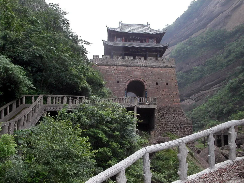
Jianmen Pass 剑门关
The cliff-walled gate on the old road to Shu that Li Bai said one man could hold
Listed sites in Guangyuan
17 sites in Guangyuan are on the official lists. Those with a page of their own link to it; the rest open as cards on the map.
- Bailin Ancient Town 柏林古镇 4A scenic area · on the map
A small town in the south of Zhaohua District that grew up around the Bailin post station on the southern branch of the old Shu Road. - Donghekou Earthquake Relics Park 东河口地震遗址公园 4A scenic area · on the map
A memorial park where the Wenchuan earthquake of 12 May 2008 brought down whole mountainsides around the village of Donghekou in Qingchuan County, burying more than 780 people. - Huangze Temple 皇泽寺 4A scenic area · National heritage site
Huangze Temple, at the foot of Wulong Mountain on the west bank of the Jialing River, is described as the only temple in China dedicated to Wu Zetian, the Tang empress who by tradition was born in Guangyuan. - Longmen Pavilion Scenic Area 龙门阁 4A scenic area · on the map
Longmen Pavilion is one of the best-known cliff-side plank-road sections of the ancient Jinniu Road near Chaotian, where the route between Qin and Shu was carried along the cliffs. - Micang Mountain Grand Canyon 米仓山大峡谷 4A scenic area · on the map
A canyon landscape in the Micang Mountains of northern Wangcang County, on the Sichuan–Shaanxi border, part of the natural divide between northern and southern China and rich in plant and animal life. - Mingyue Gorge 明月峡 4A scenic area
A narrow gorge of the Jialing River near Chaotian where six generations of routes squeeze through side by side: an ancient plank road, the Jinniu post road, a boat-haulers' towpath, the river itself, the Sichuan–Shaanxi highway and the Baoji–Chengdu railway. - Mumen Conference Site 木门会议会址 4A scenic area · National heritage site · on the map
Mumen Temple, built in the Kangxi reign of the Qing on a hillside above Mumen town in south-eastern Wangcang County, hosted a six-day conference of the Red Fourth Front Army's leaders in late June 1933, after which the army expanded rapidly in the Sichuan–Shaanxi base area. - Pingle Scenic Area 平乐旅游区 4A scenic area · on the map
A rural scenic area at Yuanba, south-east of Guangyuan city, built around Pingle Temple and said to take in the wooded Qifeng Gorge and Ziyun Lake. - Qingxi Ancient Town 青溪古城 4A scenic area · on the map
A small walled town on the upper Qingzhu River at the foot of Motian Ridge, close to where Guangyuan, Mianyang and Gansu meet, with surviving stretches of Ming city wall and lanes of timber houses in the northern Sichuan style. - Red Army City, Wangcang 红军城 4A scenic area · on the map
The old streets of Donghe, the Wangcang county town, which from November 1934 housed the Red Fourth Front Army's headquarters and more than 40 party, government and military bodies, making it the centre of the Sichuan–Shaanxi base in its final phase and the army's assembly point for the Long March. - Tangjiahe National Nature Reserve 唐家河 4A scenic area
A forested mountain reserve of about 400 km² in the far west of Qingchuan County, established in 1978 and now part of the Giant Panda National Park, ranging from about 1,100 m to almost 3,900 m. - Thousand-Buddha Cliff (Guangyuan) 千佛崖 4A scenic area · National heritage site
A cliff on the east bank of the Jialing River north of Guangyuan, honeycombed with Buddhist niches carved from the late Northern Wei to the Ming, most of them in the Tang. - Zengjiashan 曾家山 4A scenic area · on the map
A karst upland in Chaotian District, mostly 1,300–1,400 m above sea level, where stone forests, sinkholes, gorges and caves are scattered among farmland and forest. - Zhaohua Ancient Town 昭化古城 4A scenic area
A small walled town where the Bailong River meets the Jialing, known in antiquity as Jiameng; after the Qin conquered Shu and Ba in 316 BC they set up a county here, and the town calls itself the first county seat in Sichuan. - Heming Mountain Taoist Carvings, Jiange 鹤鸣山道教造像 National heritage site
A hill about 1 km east of Pu'an, the old county town of Jiange, with 21 niches and 88 carved figures, mainly Taoist, made between the Northern Wei and the Republican era. - Jueyuan Temple 觉苑寺 National heritage site · on the map
A Buddhist temple on the west side of Wulian, a town on the old Shu Road in southern Jiange County, founded in the Tang and rebuilt in 1457 under the Ming. - Zhongzipu Microlith Archaeology Museum 中子铺细石器考古博物馆 National heritage site · on the map
A museum opened in October 2024 in Zhongzi town for the Zhongzipu site, where excavations in 1990 and 1991 recovered about 20,000 finds, among them microliths (tiny flaked stone tools) from a layer dated to roughly 7,000 to 6,000 years ago.
On the map
Open Guangyuan on the illustrated map to see its outline, its places and listed sites together, and to add them to a trip.
Open Guangyuan on the map