 Atlas of China
Mount Siguniang 四姑娘山Sìgūniang Shān
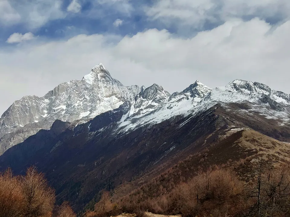
Four 'sister' snow peaks above three alpine valleys of forest, meadow and lakes
- Best time
- May–Jun, Sep–Oct
- Time needed
- 2 days
- Days to budget
- 2 days
- Stay in
- Rilong
- Region
- Sichuan
- Type
- Nature
- Listed as
- 5A scenic area, UNESCO World Heritage
Why go to Mount Siguniang
Mount Siguniang is a cluster of four snow peaks in the Qionglai range, the highest of which, Yaomei Feng, reaches 6,250 m. Three valleys fan out from Rilong (now Siguniangshan Town): Shuangqiao, with a sightseeing-bus road to its far end; Changping, a long forested trekking valley; and Haizi, a tougher high-altitude hike to alpine lakes. The area is part of the UNESCO-listed Sichuan Giant Panda Sanctuaries.
The story
Local Tibetans know the massif as Skubla, the home of a protector deity, and the Chinese name, 'Four Girls Mountain', is often explained as a sound-alike of it. Legend tells of four sisters who fought off a demon and turned into the four peaks, with the youngest, Yaomei ('little sister'), standing tallest.
What to see at Mount Siguniang
- Renshenguo Meadow 人参果坪: A meadow of several hundred mu on the Shuangqiao road, strewn with alpine flowers in spring and summer, where yaks graze. The road passes it early, so it makes a gentle first stop.
- Longzhu Lake 隆珠措: A lake in the Shuangqiao Valley formed when silt blocked a stream and drowned a stand of sea-buckthorn. Lime in the water coated their roots, so the dead trunks still stand.
- Siguniang Lake 四姑娜措: A lake said to be where the four sisters bathed, with snow peaks and standing dead trees reflected in its water. It lies in the Shuangqiao Valley.
- Red Larch Forest 红杉林: The last viewpoint on the Shuangqiao road, at 3,840 metres. These are Sichuan larches, a protected tree, set below glaciers.
- Changping Valley 长坪沟: A long forested valley of gentle gradients, followed on foot or by horse. Start at the old Lama Temple site, a good place to see all four peaks, and continue to Withered Tree Beach, a riverbed of pale dead trunks.
- Haizi Valley 海子沟: The highest of the three valleys, with alpine meadows at Guozhuangping and Chaoshanping, two of the best places to photograph the four peaks. Beyond them lie alpine lakes such as Flower Lake and Big Haizi, a day's hike or horse ride.
How to visit Mount Siguniang
Shuangqiao is the easy valley: you buy a ticket at its visitor centre, ride the sightseeing bus straight to the far end at the larch forest, then ride back and get off wherever you wish. Changping and Haizi are walks, with horses for hire. Spend one day in Shuangqiao and a second in either Changping or Haizi, after a night to acclimatise. Half a day is enough for Shuangqiao alone.
How to get to Mount Siguniang
Rilong is about 4 hours by road from Chengdu via Dujiangyan, the Wolong panda reserve (the Shenshuping panda base makes a good stop) and the Balangshan tunnel. Buses from Chengdu's Chadianzi bus station towards Xiaojin stop in town.
Where to stay
Siguniangshan Town (formerly Rilong) at the foot of the three valleys has guesthouses and hotels along its main street. Sleeping there for a night helps you adjust to the altitude before the high valleys.
What to eat
- Wind-dried yak meat 风干牦牛肉: Yak meat dried in the cold mountain air, crisp and chewy, eaten grilled or raw as a snack.
- Tibetan yak hotpot 藏式牦牛火锅: A hotpot in a broth made from yak bones, with yak meat, pork slices, wild mushrooms and vegetables.
- Butter tea 酥油茶: The staple Tibetan drink, tea churned with yak butter and salt. It is salty and warming at altitude.
Tips for visiting Mount Siguniang
- Rilong sits at about 3,200 m and the trails climb higher, so spend a night in town before tackling Changping or Haizi.
- Start early: entry to Changping and Haizi closes in the early afternoon, and tickets for the October holidays can sell out, so book ahead online.
- Stay on the marked routes; treks across to other valleys and climbs on the peaks need advance approval and a registered guide.
Nearby
- Mount Qingcheng 青城山 70 km
A cradle of Taoism, where forest stairways climb past temples and cave shrines - Dujiangyan Irrigation System 都江堰 70 km
A 2,200-year-old waterworks that tamed the Min River without a dam and still runs today - Taoping Qiang Village 桃坪羌寨 90 km
A lived-in Qiang stone village of watchtowers, rooftop paths and hidden water channels - Jiaju Tibetan Village 甲居藏寨 90 km
Painted Gyalrong Tibetan farmhouses on a mountainside, in a valley of ancient towers - Mount Mengding 蒙顶山 100 km
Misty tea terraces and an imperial tea garden where tea growing is said to have begun
On the map
Open Mount Siguniang on the illustrated map to see the terrain around it, what else is close, and to add it to a trip and plan the days.
Open Mount Siguniang on the map