 Atlas of China
Wudang Mountains 武当山Wǔdāng Shān
Taoist palaces strung along forested ridges, and the legendary birthplace of tai chi
- Best time
- Apr–May, Sep–Nov
- Time needed
- 1–2 days
- Days to budget
- 1½ days
- Stay in
- Shiyan
- Region
- Hubei
- Type
- Culture
- Listed as
- 5A scenic area, National heritage site, UNESCO World Heritage
Why go to Wudang Mountains
The Wudang Mountains are one of China's most sacred Taoist ranges, with Ming-dynasty palaces and temples strung along forested ridges up to the bronze Golden Hall on the highest peak. Taoist priests still live and train here, and martial-arts schools at the foot of the mountain teach visitors the slow, flowing forms of Wudang tai chi.
The story
Legend credits the hermit Zhang Sanfeng with inventing tai chi here after watching a crane fight a snake. In the early 1400s the Yongle emperor, who believed the Taoist god Zhenwu had protected him, sent a huge workforce to build the mountain's palaces.
What to see at Wudang Mountains
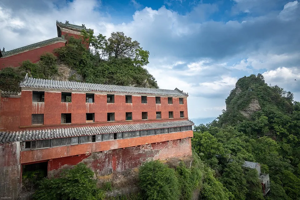
- Taizi Slope 太子坡: A temple complex stepped up the hillside, known for its zigzag red wall, and often the first stop after the shuttle.
- Purple Cloud Temple 紫霄宫: A large palace complex first built in the early 12th century and rebuilt in 1413 under the Ming; conservation work runs into 2027 but the temple has stayed open.
- Nanyan Palace 南岩宫: A temple complex built into a cliff face, with sweeping views over the valley.
- Golden Hall 金殿: A gilded bronze hall from 1416 on the summit, Wudang's most famous building.
- Golden Summit 金顶: The final climb to Tianzhu Peak, the highest point on the mountain, reached by cable car or a hike.
How to visit Wudang Mountains
Private cars cannot enter the core area, so use the shuttle from the main entrance to stops such as Taizi Slope, Purple Cloud and Nanyan. A common plan runs Taizi Slope, Purple Cloud and Nanyan on the first day, then the cable car or an early hike to the summit and the Golden Hall. One day covers the highlights if you ride the cable car; two days allow sunrise at the top and the slower sights.
How to get to Wudang Mountains
Wudangshan has its own high-speed rail station, roughly 2–3 hours from Wuhan. From the town at the foot of the mountain, park buses carry visitors up to the cable car and summit trails.
Where to stay
Stay in Wudangshan town at the foot of the mountain, where the shuttles start and the snack streets are; staying overnight lets you reach the summit for sunrise. Shiyan city is the fallback.
What to eat
- Taoist vegetarian meal 道家素斋: Vegetarian dishes cooked in temple style, such as tofu and mushroom soup, served near the main temples.
- Polygonatum tea 黄精茶: A tea from the Polygonatum root, a mountain herb sold in the shops of Wudangshan town.
Tips for visiting Wudang Mountains
- Start early: park buses and the cable car build long queues by mid-morning.
- Ride the Qiongtai cable car to save your legs, then walk the final stairway to the Golden Hall.
- Several schools near the mountain run short tai chi classes for complete beginners.
Nearby
- Shennongjia 神农架生态旅游区 120 km
Primeval forest and alpine meadow on the roof of central China, a UNESCO forest reserve
Also within 30 km: Wudang Daming Peak 武当大明峰 (10 km), Wudang South Pilgrim Path 武当山南神道 (10 km), Wudang Happy Valley 武当山快乐谷 (20 km), Donggou Red Tourism Area 东沟红色旅游景区 (20 km), Yunlong Valley, Sai Wudang 赛武当云龙谷 (30 km).
On the map
Open Wudang Mountains on the illustrated map to see the terrain around it, what else is close, and to add it to a trip and plan the days.
Open Wudang Mountains on the map