 Atlas of China
Lu'an 六安Lù’ān
Tea slopes, big reservoirs and the wooded peaks of the Dabie Mountains
About Lu'an
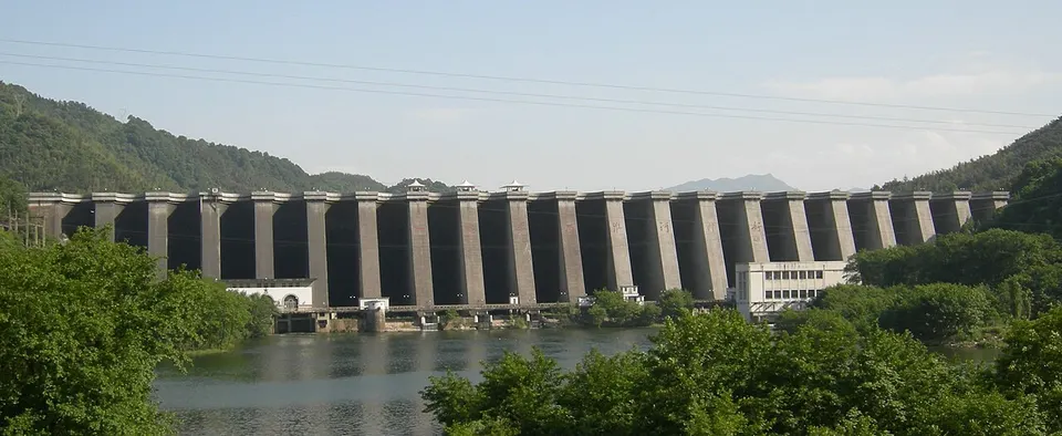
Lu'an, pronounced 'Lù-ān', climbs from farmland on the watershed between the Huai and the Yangtze into the Dabie Mountains on the Hubei border. Walkers head for Tiantangzhai, the range's second-highest peak, and the valleys hold big reservoirs such as Wanfo Lake and the Foziling Reservoir, whose dam, finished in 1954, was the first large water project of the People's Republic. The slopes grow Lu'an guapian, a green tea made from single leaves rather than buds.
What to eat in Lu'an
- Lu'an guapian tea (六安瓜片)
Listed sites in Lu'an
28 sites in Lu'an are on the official lists. Those with a page of their own link to it; the rest open as cards on the map.
- Tiantangzhai 天堂寨 5A scenic area · on the map
Tiantangzhai, at 1,729 m the second-highest peak of the Dabie Mountains, stands on the Anhui–Hubei border on the watershed between the Huai and Yangtze rivers. - Wanfo Lake 万佛湖 5A scenic area · on the map
Wanfo Lake is the scenic name of Longhekou Reservoir, built by around 100,000 labourers mobilised from across Shucheng County from 1958 and largely finished in 1970 as a flood-control and irrigation source for the Pishihang irrigation district. - Anhui Dream Ocean World 梦幻海洋大世界 4A scenic area · on the map
Anhui Dream Ocean World is a commercial indoor aquarium of about 10,000 m² in the Zhedong trade centre in central Lu'an, opened by private investors as a marine-life exhibition and science-education venue. - Baimajian (Main Peak of the Dabie Mountains) 白马尖 4A scenic area · on the map
Baimajian, at 1,777 m the highest summit of the Dabie Mountains, rises in the far south-west of Huoshan County inside the Dabie Mountains nature reserve. - Dabieshan Fengqing Valley 大别山风情谷 4A scenic area · on the map
Fengqing Valley is a forested valley scenic area in Hongshan village, next to the Dabieshan Grottoes, with a narrow rock cleft, waterfalls dropping into a lake, a stream with sandy banks, bamboo groves and a stand of nanmu trees. - Dabieshan Grottoes Scenic Area 大别山石窟 4A scenic area · on the map
The Dabieshan Grottoes are natural rock shelters and caves, not carved shrines, in a wooded scenic area with a 15 km² core in Hongshan village, part of the Dabie Mountains (Lu'an) National Geopark. - Dawan Village 大湾村 4A scenic area · on the map
Dawan is a tea-growing mountain village in Huashi township whose 2.5 km² scenic area combines tea gardens, farm guesthouses and a group of twelve ancient sandalwood trees with sites of the revolutionary period. - Dongshisun Scenic Area 东石笋 4A scenic area · on the map
Dongshisun is a hill scenic area south of Maotanchang town whose slopes are built of stacked slabs of metamorphic rock, rising to just over 760 m. - Dushan Revolutionary Sites 独山革命旧址群 4A scenic area · National heritage site · on the map
Dushan is a market town in the Dabie foothills where a Communist-led uprising broke out in 1929, in the years when the Hubei–Henan–Anhui Soviet base was being formed. - Foziling Reservoir 佛子岭水库 4A scenic area · National heritage site
Foziling Reservoir on the upper East Pi River was built between 1952 and 1954 as the first large water-conservancy and hydropower project of the People's Republic, and is officially called the 'first dam of New China'. - Hengpaitou Headworks 横排头 4A scenic area · on the map
Hengpaitou, on the Pi River at Subu town, is the head of the Pi River main canal of the Pishihang irrigation district, a large scheme serving farmland in Anhui and Henan. - Huoshan Grand Canyon Rafting 霍山大峡谷 4A scenic area · on the map
The Huoshan Grand Canyon is a rafting and adventure area on the Kongque River, where an 8 km run drops 160 m in total, with a largest single drop of 19 m, over smooth patterned rock beds between bamboo-covered slopes. - Jinzhai Red Army Square 金寨红军广场 4A scenic area · on the map
Red Army Square in Jinzhai county town is a memorial park on the county's revolutionary history, laid out around a monument tower to revolutionary martyrs. - Jiugongzhai 九公寨 4A scenic area · on the map
Jiugongzhai is a wooded hill in Shibanchong township, counted among the eight traditional sights of Lu'an and long associated with Buddhism. - Linhuaigang Flood Control Project 临淮岗 4A scenic area · on the map
Linhuaigang is a flood-control scheme on the Huai River, described by the Lu'an government as the largest water-control project on the river, with a main dam, auxiliary dams, a diversion channel, a ship lock and sluices stretching some 78 km across the river plain north of Huoqiu. - Liuwan Qingxia Gorge Park 六万情峡 4A scenic area · on the map
Liuwan Qingxia is a commercial leisure complex built around a wooded gorge in Luoerling town, rated 4A in 2025 and themed partly on the area's anti-Japanese war history. - Longjin Xidi Gorge 龙津溪地 4A scenic area · on the map
Longjin Xidi is a gorge scenic area about 8.5 km long in the hills of Quanjun township, developed by a private tourism company across the river from Xijiuhua Shan in Henan. - Meishan Reservoir 梅山水库 4A scenic area · on the map
Meishan Reservoir on the upper Shi River is one of the large reservoirs built to control the Huai River, supplying flood control, power and water for 3.83 million mu of farmland in Anhui and Henan. - Nanyue Shan 南岳山 4A scenic area · on the map
Nanyue Shan is a 405 m hill rising 2.5 km south of Huoshan county town, steep on its southern face and gently sloping to the north. - Tongluozhai 铜锣寨 4A scenic area · on the map
Tongluozhai is a steep, isolated peak of 1,096 m in the heart of the Dabie Mountains, within a 92 km² scenic area of pine-clad crags and oddly shaped rocks. - Wanfo Mountain 万佛山 4A scenic area · on the map
Wanfo Mountain is a forested range in south-western Shucheng County, a national forest park and geopark of about 50 km² whose main peak, Laofoding, reaches 1,539 m. - Wanxi Grand Rift Valley 皖西大裂谷 4A scenic area · on the map
The Wanxi Grand Rift is a deep V-shaped cleft through a wooded hill in Taipingqiao village, part of the Dabie Mountains (Lu'an) National Geopark. - Wanxi Museum 皖西博物馆 4A scenic area · on the map
The Wanxi Museum is Lu'an's city museum, founded in 1980, whose present Hui-style building opened in 2011 and partly reopened in August 2025 after a refit. - Xianghongdian Reservoir 响洪甸水库 4A scenic area · on the map
Xianghongdian Reservoir on the West Pi River was built between 1956 and 1958 behind an 87.5 m concrete gravity-arch dam for flood control, irrigation and power, and is a main source of the Pishihang irrigation district. - Yanzihe Grand Canyon 燕子河大峡谷 4A scenic area · on the map
Yanzihe Grand Canyon is a forested gorge about 5.8 km long in Yanzihe town, adjoining the Tiantangzhai area and part of the Dabie Mountains geopark. - Youran Lanxi Resort 悠然蓝溪 4A scenic area · on the map
Youran Lanxi is a large resort complex in Sanshipu town built by the Xingmao property group, laid out round a lake with new Chinese-style buildings, gardens, a big fountain square and stone-inscription galleries. - Youran Nanshan Resort 悠然南山 4A scenic area · on the map
Youran Nanshan is a sports and leisure resort in Zhongdian town built by a property developer, with Mediterranean-style buildings, hotels and inns. - Li Family Manor 李氏庄园 National heritage site · on the map
The Li Family Manor, also called Lijiawei, is a moated landlord's estate begun in 1856 by the Li clan, who by the late Qing held land across western Anhui and neighbouring Henan.
On the map
Open Lu'an on the illustrated map to see its outline, its places and listed sites together, and to add them to a trip.
Open Lu'an on the map