 Atlas of China
Ganzhou 赣州Gànzhōu
Hakka fortress houses, Song-dynasty drains and Buddhist cliff carvings
About Ganzhou
Ganzhou, the main city of southern Jiangxi and a Hakka region, stands where the Zhang and Gong rivers meet to form the Gan. Its old centre keeps a Song-dynasty city wall and the Fushou Ditch, an 11th-century drainage network still partly in use, and the Buddhist carvings of Tongtian Rock lie just outside. Farther afield are Longnan's Guanxi Walled Houses, built by Hakka families as fortified homes, the forests of Sanbaishan, and Ruijin, capital of the Chinese Soviet Republic from 1931 to 1934.
What to eat in Ganzhou
- Ningdu three-cup chicken (宁都三杯鸡)
- Ruijin beef soup (瑞金牛肉汤)
- Nan'an cured duck (南安板鸭)
Listed sites in Ganzhou
59 listed sites are in Ganzhou. These are the 40 rated 5A or 4A; see all 59 in the Jiangxi list.
- Ruijin Cradle of the Republic Scenic Area 瑞金共和国摇篮景区 5A scenic area · National heritage site · on the map
Ruijin was the seat of the Chinese Soviet Republic's central government from late 1931 until the Long March began in 1934, and this scenic area gathers four sets of sites from that period. - Sanbaishan Scenic Area 三百山 5A scenic area · on the map
A forested mountain area in south-eastern Anyuan, on the Jiangxi–Guangdong border, where the Dongjiang (East River), a main water source for Hong Kong and Guangdong, rises. - Anjishan Forest Park, Longnan 安基山 4A scenic area · on the map
Anjishan is a provincial forest park in Chenglong town, west-south-west of Longnan, with dense woodland and a stretch of river. - Baguanao 八卦脑 4A scenic area · on the map
A high-mountain scenic area in Gaotian town, in the north-east of Shicheng county, promoted by the county as a high-altitude azalea viewing spot. - China (Quannan) Climbing Town 中国(全南)攀岩小镇 4A scenic area · on the map
A sports-tourism complex in Chengxiang town, on the north-western side of Quannan, built around rock climbing, with a 15 m competition wall, four zones and eleven activity areas, plus a national training base for young climbers. - Cuiweifeng 翠微峰 4A scenic area · on the map
A cluster of red-sandstone Danxia peaks and cliffs on the north-western edge of Ningdu town, with a path to the summit at Lingxiao Pavilion and a glass walkway on the mountainside. - Dongsheng Wei 东生围 4A scenic area · National heritage site
A large square Hakka walled house built from 1842 in the Qing dynasty and extended three times over 25 years, listed as a national heritage unit in 2013. - Gan River Source Scenic Area 赣江源 4A scenic area · on the map
A forested mountain area in Ganjiangyuan town, in the far south of Shicheng county, named for the headwaters of the Gan River that Shicheng counts as the river's source. - Guanxi Walled Houses 关西围屋 4A scenic area · National heritage site
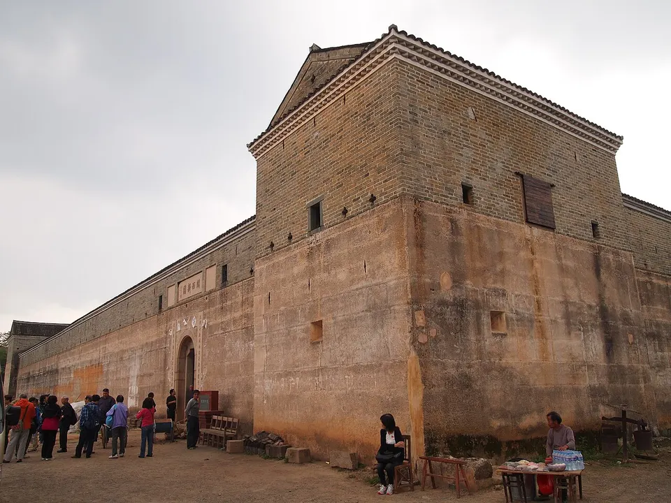
Guanxi Xinwei is a Hakka walled mansion begun in 1798 and completed in 1827 by Xu Mingjun, a near-square block 83 m by 95 m inside 10 m-high walls, with watchtowers at the four corners and 27 gun loops in the walls. - Gushan Scenic Area, Xinfeng 谷山 4A scenic area · on the map
A wooded hill park on the south-western edge of Xinfeng town, laid out as a forest park and topped by the Xinfeng Pavilion (Xinfeng Ge). - Hakka Culture City, Ganxian 客家文化城 4A scenic area · on the map
A Hakka-culture complex in the south of Meilin, the seat of Ganxian district, laid out as a group of Hakka-style buildings for ceremonies, exhibitions, trade and leisure, and home to the Jiangxi Hakka Museum. - Hanxianyan Scenic Area 汉仙岩 4A scenic area
A red-sandstone Danxia hill and gorge area in the south of Huichang county, named after the legend that Han Zhongli, one of the Eight Immortals, attained immortality here. - Hongxinggu Study Campus, Xingguo 红兴谷 4A scenic area · on the map
A study and training campus of about 900 mu (60 hectares) on the north-western outskirts of Xingguo town, built by the Jiangxi expressway group and opened in 2023. - Huichang Theatre Town 会昌戏剧小镇 4A scenic area · on the map
A theatre quarter of about 128 mu (roughly 8.5 hectares) in Huichang town, developed with the director Stan Lai, whose father came from Huichang, and opened in January 2024. - Jiangnan Song City 江南宋城 4A scenic area · on the map
A historic-quarter tourist area of about 50 ha in the northern part of Ganzhou's old city, whose landmarks are Yugutai, the hilltop pavilion on the highest point of the urban area, and Bajing Terrace at the meeting of the Zhang and Gong rivers. - Jiuqu Resort, Dingnan 九曲度假村 4A scenic area · on the map
A holiday resort on the Jiuqu river at Tianjiu town, Dingnan county, set in bamboo woods with a waterfall, boat rides on its lake and a street presenting Hakka intangible heritage. - Long March Departure Sites, Yudu 中央红军长征出发地 4A scenic area · National heritage site
In October 1934 more than 86,000 Red Army troops gathered around Yudu and crossed the Yudu (Gong) River at night at several crossing points, the start of the Long March. - Luohan Rock, Ruijin 罗汉岩 4A scenic area · on the map
A red-sandstone (Danxia) scenic area around the Chenshi Reservoir in Rentian town, north-east of Ruijin, where cliffs and oddly shaped rock stacks rise beside a lake. - Mei Pass 梅关 4A scenic area · National heritage site
A mountain pass on the Meiling ridge between Jiangxi and Guangdong, on the old trade road that the Tang chancellor Zhang Jiuling had cut through the Dayu range in 716, about 5 m wide and 8 km long with a paved surface. - Nan Wudang Mountain 南武当山 4A scenic area · on the map
A national scenic area of 13.5 sq km in Wudang town, near the Guangdong border, where 99 red-rock peaks rise from the valley beside National Road 105 to a main summit of 864 m. - Nankang Furniture Town 南康家居小镇 4A scenic area · on the map
A purpose-built furniture-industry town in Jingba town, planned over 5 km² with a 2 km² core around a lake of more than 300 mu. - Pingshan Scenic Area, Yudu 屏山 4A scenic area · on the map
Pingshan is a mountain in the far south of Yudu county whose summit, at 1,314 m the highest in the county, is covered by about 50,000 mu (roughly 3,300 hectares) of natural grassland. - Qianxin Town, Longnan 虔心小镇 4A scenic area · on the map
A hill resort town in Dongkeng village, Lintang township, developed as a wellness and holiday destination with tea growing and forest-based activities; about 100,000 mu (roughly 6,700 hectares) of forest land has been leased to it for that use. - Qinglongyan Scenic Area 青龙岩 4A scenic area · on the map
Danxia sandstone cliffs in Nanqiao town, south of Xunwu county town, developed as a hot-spring tourist resort. - Shangbao Terraces 上堡梯田 4A scenic area · on the map
Rice terraces of about 51,000 mu (some 3,400 ha) climbing the mountains of north-western Chongyi across Shangbao, Fengzhou and Sishun townships, with a history of more than 2,200 years. - Site of the Soviet Area Central Bureau, Xiaobu 中共苏区中央局旧址 4A scenic area · National heritage site · on the map
A former Gong clan ancestral hall, known locally as Xinwu ('new house'), in Chikan village beside Xiaobu town: a south-facing brick-and-timber building restored in 2008. - Taoyuan Lejing Park, Dingnan 桃源乐境 4A scenic area · on the map
Taoyuan Lejing is a landscaped hill park on the edge of Dingnan town, themed on the 'Peach Blossom Spring' story by the poet Tao Yuanming. - Tianlong Mountain, Quannan 天龙山 4A scenic area · on the map
A forested mountain scenic area in Jinlong town, Quannan county, with trails through pine woodland. - Tongtian Rock 通天岩 4A scenic area · National heritage site
A red-sandstone (Danxia) hill in Shuixi town, north-west of Ganzhou, whose caves and niches hold hundreds of Buddhist statues and well over a hundred inscriptions from the Song dynasty to the Republic, among them Wang Yangming's. - Tongtianzhai, Shicheng 通天寨 4A scenic area · on the map
A Danxia (red-sandstone) scenic area in Qinjiang town, south-east of Shicheng, rising to a summit of about 600 m. - Wulong Hakka Folk Park 五龙客家风情园 4A scenic area · on the map
A large leisure park of more than 2,000 mu (about 130 ha), with some 300 mu of water, on the south-eastern edge of Ganzhou's urban area. - Xingguo Generals' Park 苏区干部好作风纪念园 4A scenic area · on the map
A memorial park of about 508 mu (34 hectares) on the south-western edge of Xingguo town, built around the Soviet-Area Cadres' Work Style exhibition hall, which shows 213 relics, 18 oil paintings and 12 large reconstructed scenes from the Soviet period, including a survey Mao Zedong made in Changgang township. - Xunwu Investigation Site 寻乌调查旧址 4A scenic area · National heritage site · on the map
A two-storey house of timber and earth with cobble-and-lime walls and a wooden arcade on its south front, built in 1917 as the home of an American missionary at the Matigang Catholic church in the county town. - Yangming Lake 阳明湖 4A scenic area · on the map
A reservoir of about 31 sq km on the border of Shangyou and Chongyi counties, formed by damming the Shangyou River and formerly known as Doushui Lake. - Yangming Xingu Scenic Area 阳明心谷 4A scenic area · on the map
A landscaped park of about 113 ha on the east bank of the Tao River north of Longnan town, built on reclaimed mining land around the Yushi Xianyan cliff and opened on trial in June 2023. - Yangmingshan Forest Park, Chongyi 阳明山国家森林公园 4A scenic area · on the map
A forest park of about 69 sq km on the Hunan–Guangdong–Jiangxi border, rising to 1,259.5 m beside the county town of Chongyi. - Yashan, Dayu 丫山 4A scenic area · on the map
A mountain resort area of more than 30,000 mu in Huanglong town, inside Meiguan National Forest Park and named after its highest peak, Shuangxiu, whose Y-shaped summit gives the place its name (ya means a fork). - Yaxi Ancient Village 雅溪古村 4A scenic area · on the map
A Hakka village in Longyuanba town, north of Quannan, notable for two walled houses: Fuxing Wei, built of rammed earth, and Yafeng Wei, built of stone. - Yuxue Ruijing Scenic Area 浴血瑞京 4A scenic area · on the map
A red-tourism park in Jieyuan village, west of Ruijin, built around the live outdoor show Yuxue Ruijing, which the provincial tourism department presented in 2020 as the province's first real-scene performance project that visitors can take part in. 'Ruijing' was the name by which Ruijin was known as the capital of the Chinese Soviet Republic in the early 1930s.
On the map
Open Ganzhou on the illustrated map to see its outline, its places and listed sites together, and to add them to a trip.
Open Ganzhou on the map