 Atlas of China
Bazhong 巴中Bāzhōng
Tang Buddhas on a city cliff, and beech forests that blaze red each autumn
About Bazhong
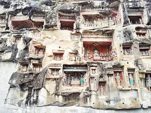
Bazhong, whose name means 'centre of Ba' after the ancient Ba kingdom, lies among the forested Daba and Micang mountains on the Shaanxi border, off Sichuan's main tourist routes. On the southern edge of the city, the Nankan Grottoes hold about 2,700 painted Buddhist figures, most of them carved in the Tang dynasty. To the north, Guangwu Mountain, part of a UNESCO Global Geopark, is known for its limestone peaks and autumn colour, and Enyang Ancient Town keeps stone-paved lanes of timber-fronted shops.
Listed sites in Bazhong
16 sites in Bazhong are on the official lists. Those with a page of their own link to it; the rest open as cards on the map.
- Guangwu Mountain 光雾山 5A scenic area · 4A scenic area · on the map
Guangwushan covers more than 400 km² of the Micang range on the Sichuan–Shaanxi border, with limestone peaks, deep valleys, caves and large tracts of beech forest rising to 2,507 m. - Baiyi Ancient Town 白衣古镇 4A scenic area · on the map
Baiyi is an old trading town on the Ba River in southern Pingchang county that grew along the Micang trade road between Sichuan and Shaanxi. - Enyang Ancient Town 恩阳古镇 4A scenic area · on the map
Enyang is an old market and river town on the Enyang River, about 15 km south-west of central Bazhong. - Huahu Lake, Bazhou 山水化湖 4A scenic area · on the map
A lake area around Huacheng Reservoir in Huacheng town, about 20 km north-east of central Bazhong, listed as a National Water Conservancy Scenic Area. - Huangjia Mountain, Pingchang 皇家山 4A scenic area · on the map
A tea-growing hill area of about 12.6 km² spanning Xixing and Tuya towns, where more than 400 hectares of tea bushes follow the slopes and low clouds often settle in the valleys. - Jiuzhaishan Park, Bazhong 九寨山 4A scenic area · on the map
A landscaped hill park on the eastern side of Bazhong, in the city's economic development zone near Bazhong East railway station. - Kongshan Basin 空山天盆 4A scenic area · on the map
Kongshan is a high upland basin of meadows, farmland and forest ringed by mountains in northern Tongjiang county; 'Tianpen' means 'sky basin'. - Nankan Grottoes 南龛石窟 4A scenic area · National heritage site
On Nankan Mountain, on the southern edge of central Bazhong, more than 170 niches holding about 2,700 painted Buddhist figures were cut into the cliffs, most of them in the Tang dynasty. - Nantianmen, Pingchang 南天门 4A scenic area · on the map
A forested hill area of about 18.5 km² in Wumu town, once a stage on the Micang ancient road and a military strongpoint of the Sichuan–Shaanxi revolutionary base area. - Nuoshui River Scenic Area 诺水河 4A scenic area · on the map
The Nuoshui (Xiaotong) River cuts through the limestone of the Micang range in northern Tongjiang county, and its scenic area is known for karst caves, gorges and forested valleys. - Sima Water Town, Pingchang 驷马水乡 4A scenic area · on the map
A leisure area around Sima town, on the border of Pingchang County and Bazhou District, built around an artificial lake and wetlands. - Wangping Red Army Martyrs' Cemetery 王坪红军烈士陵园 4A scenic area · National heritage site · on the map
This hillside cemetery at Wangping in Tongjiang county was begun by the Red Fourth Front Army in 1934 and, after scattered graves from across the county were moved here in 2012, holds about 25,000 Red Army dead. - Bairuxi Grottoes 白乳溪石窟 National heritage site · on the map
Bairuxi is a group of Tang-dynasty Buddhist niches carved into the rock in southern Tongjiang county. - Qianfoyan Grottoes, Tongjiang 通江千佛岩 National heritage site · on the map
This cliff in Qianfo village, just west of Tongjiang town, holds 54 niches with more than 3,000 Buddhist figures, carved mainly in the Tang dynasty. - Red Fourth Front Army Headquarters Site 红四方面军总指挥部旧址 National heritage site · on the map
From the winter of 1932 to the spring of 1935 the Red Fourth Front Army used Tongjiang's Confucian temple as its headquarters while it held the Sichuan–Shaanxi revolutionary base. - Shimen Temple Cliff Carvings 石门寺摩崖造像 National heritage site · on the map
A group of Tang-dynasty Buddhist niches cut into the rock at the Shimen Temple site in Bazhou District, east of central Bazhong, and listed as a national heritage site in 2019.
On the map
Open Bazhong on the illustrated map to see its outline, its places and listed sites together, and to add them to a trip.
Open Bazhong on the map