 Atlas of China
Aksu 阿克苏Ākèsū
Kucha's painted caves, red-rock canyons and the Tian Shan's highest peak
About Aksu
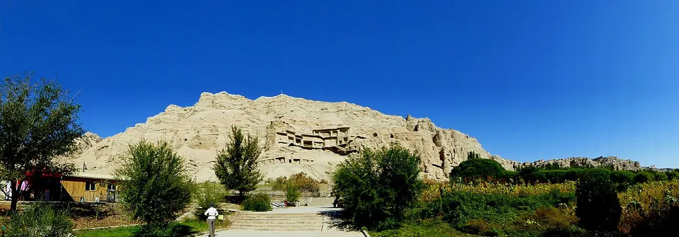
Aksu, Turkic for 'white water', runs from Tomur Peak, the highest summit of the Tian Shan, down to the Tarim River on the edge of the Taklamakan. Around Kuqa lay the Buddhist kingdom of Kucha, whose cave temples at Kizil and Kumtura keep murals from as early as the 3rd century, near the ruined Subashi monastery and a Han beacon tower at Kizilgaha. The Tianshan Tomur scenic area, rated 5A in 2024, takes in red-rock canyons and glacier views below the peak.
What to eat in Aksu
- Aksu apples (阿克苏苹果)
Listed sites in Aksu
33 sites in Aksu are on the official lists. Those with a page of their own link to it; the rest open as cards on the map.
- Tianshan Tomur Scenic Area 天山托木尔 5A scenic area · on the map
Tianshan Tomur is a 752 km² mountain scenic area in Wensu County below Tomur Peak, at 7,443.8 m the highest summit of the Tian Shan, and in December 2024 it became Aksu Prefecture's first 5A area. - Aksu Museum 阿克苏地区博物馆 4A scenic area · on the map
The prefecture museum of Aksu, also called the Aksu Prefecture Museum and Heritage Institute, opened in its present colourful building in 2009 and holds about 2,000 objects on the history of the Aksu region and the Kucha kingdom. - Aksu National Wetland Park 阿克苏国家湿地公园 4A scenic area · on the map
A wetland park beside Aksu city covering about 5,000 mu (330 ha), of which some 1,800 mu is water, laid out as 23 linked lakes with paths and five viewing platforms. - Daolang Tribe Scenic Area, Awat 刀郎部落 4A scenic area · on the map
A folk-culture scenic area in Awat County themed on Dolan (刀郎) culture, the tradition behind Dolan muqam music, set among old desert-poplar woodland by a river. - Desert Flower Sea, Xinhe 沙漠花海 4A scenic area · on the map
A desert leisure park of about 3,000 mu (some 200 ha) opened at the end of 2016 on a patch of dunes surrounded by oasis farmland in Qiaolepaibage village, Xinhe County. - Duolang River Scenic Area, Aksu 多浪河 4A scenic area · on the map
The landscaped banks of the Duolang River through Aksu city, a 4A scenic area since 2018, with promenades, pavilions such as the Gumo Pavilion and a small amusement area. - Jiayi Village 加依村 4A scenic area · on the map
Jiayi is a village in Xinhe County known for making traditional Uyghur musical instruments, a craft it has practised for more than 300 years; nearly half of its roughly 290 households build instruments such as the dutar, ajek and rawap. - Kangqi Wetland, Baicheng 康其湿地 4A scenic area · on the map
A wetland in Arele village, Kangqi township, where the Karasu and Muzat rivers meet east of Baicheng county town, developed for rural tourism since 2018. - Kekeya Memorial Hall 柯柯牙纪念馆 4A scenic area · on the map
A memorial hall at the core of the Kekeya greening project, which since the 1980s has planted forest across the gravel desert that once sent dust storms into Aksu. - Kizil Caves 克孜尔千佛洞 4A scenic area · National heritage site
Kizil is the largest Buddhist cave complex of the ancient Kucha kingdom and among the earliest in China, cut into cliffs above the Muzat River from about the 3rd century until the 8th–9th centuries. - Kizilgaha Beacon Tower 克孜尔尕哈烽燧 4A scenic area · National heritage site · on the map
A Han-dynasty beacon tower of rammed earth laid in layers with reeds and branches, still about 16 m high, standing on gravel desert north-west of Kuqa. - Kuqa Palace 库车王府 4A scenic area · on the map
Kuqa Palace is a reconstruction, completed in 2004, of the residence of the Kuqa princes, a hereditary title first granted under the Qianlong Emperor in the 18th century and held by twelve generations. - Qilan Ancient City, Kalpin 齐兰古城 4A scenic area · National heritage site · on the map
Qilan Ancient City is a Qing-dynasty ruin site in the desert about 7 km east of Qilan village in Kalpin County, listed nationally as the Konaqilan ruins. - Sea-Buckthorn Forest Wetland Park, Wushi 沙棘林 4A scenic area · on the map
A wetland park in Wushi County built around a large stand of wild sea-buckthorn, with a boardwalk of about 5 km winding through the thickets beside streams and springs. - Tang Anxi Protectorate Culture Park, Xinhe 唐安西都护府文化园 4A scenic area · on the map
A modern culture park in Xinhe county town named after the Tang dynasty's Anxi Protectorate, rated 4A in 2023. - Tarim River Wetland and Poplar Forest, Shaya 塔里木河湿地 4A scenic area · on the map
A scenic area of wetland and natural desert-poplar (Populus euphratica) forest beside the Tarim River south of Shaya county town. - Tianshan Mysterious Grand Canyon 天山神秘大峡谷 4A scenic area · on the map
A narrow canyon about 5.5 km long cut into red-brown sedimentary rock on the southern flank of the Tian Shan, part of a national geopark; locals call it Kizilya, 'red cliffs'. - Tianshan Sacred Tree Garden 天山神木园 4A scenic area · on the map
A grove of ancient trees in a spring-fed oasis at about 1,700 m in the Tian Shan foothills of Wensu County, covering some 600 mu (40 ha). - Weigan River Eco-Cultural Scenic Area, Shaya 渭干河生态文化旅游景区 4A scenic area · on the map
A park area on the Weigan River in Shaya, rated 4A in 2023, centred on Yanming Lake People's Park and its lakeside wetland. - Yanqi Pastoral Complex, Shaya 雁栖·田园综合体 4A scenic area · on the map
An agri-tourism complex built around a modern agricultural science park in Gulebage town, Shaya County, rated 4A in 2024. - Yanquanshan Park, Wushi 燕泉山 4A scenic area · on the map
Yanquanshan is a landscaped scenic park at the western end of Wushi county town, used mainly by local residents for walks. - Ancient Kucha City Ruins 龟兹故城 National heritage site · on the map
These are the remains of the walled capital of the ancient Kucha kingdom, identified as Yancheng of the Han dynasty and Yiluolu of the Tang, within today's Kuqa city. - Kesiletage Buddhist Temple Ruins 克斯勒塔格佛寺遗址 National heritage site · on the map
The ruins of a Kucha-style Buddhist monastery of the Northern Dynasties to Tang period, built in terraces up a bare hill near Kalpin, with a main hall, monks' rooms and a stupa base. - Kizilgaha Caves 克孜尔尕哈石窟 National heritage site · on the map
Kizilgaha is a group of 54 Buddhist caves, 46 of them numbered, cut into gully cliffs north-west of Kuqa from the 5th century and one of the main cave sites of the ancient Kucha kingdom. - Kumtura Caves 库木吐喇千佛洞 National heritage site
Kumtura is the second-largest cave group of ancient Kucha after Kizil: 112 caves cut between the 5th and 11th centuries along about 3 km of cliffs above the Weigan (Muzat) River. - Kuqa Grand Mosque 库车大寺 National heritage site
Kuqa's main mosque stands on a mound on the north-western side of the old town; tradition dates its founding to the 16th century, and the present prayer hall, gatehouse and court building come from a rebuilding completed in 1932 after a fire. - Liu Pingguo Inscription 刘平国刻石 National heritage site · on the map
An Eastern Han cliff inscription of about 105 characters in clerical script, cut in 158, records how Liu Pingguo, a general of the Kucha kingdom, had men cut the rock and build a pass station at the mouth of the Boziklig gully. - Molana Arshidin Mazar 默拉纳额什丁麻扎 National heritage site · on the map
The shrine complex of Arshidin, the 14th-century Sufi teacher credited with bringing the Moghul khan Tughlugh Timur to Islam, lies between Kuqa's old and new towns. - Simsim Caves 森木塞姆千佛洞 National heritage site
Simsim is the easternmost of the Kucha cave groups: 52 caves spread over about 800 m at the mouth of a gorge in the Qoltag hills, cut from around the 4th century and abandoned by about the 9th. - Subashi Temple Ruins 苏巴什佛寺遗址 National heritage site
Subashi ('head of the water' in Uyghur), recorded in Chinese sources as the Zhaohuli monastery, was the largest Buddhist monastery of the Kucha kingdom in the Wei-Jin period, at the foot of the Qoltag hills north-east of Kuqa. - Tonggusibashi City Ruins 通古斯巴西城址 National heritage site · on the map
The walls of a Tang-dynasty town, about 250 by 230 m and up to 7 m high with bastions and corner towers, stand on the alluvial plain of the Weigan River in southern Xinhe County. - Wushitu'er and Xiahetu'er Ruins 乌什吐尔和夏合吐尔遗址 National heritage site · on the map
Two ruined walled sites face each other across the mouth of the Weigan (Muzat) River just south of the Kumtura Caves, with remains mainly of the Wei-Jin to Tang periods. - Youyi Road Tombs, Kuqa 库车友谊路墓群 National heritage site · on the map
A cemetery of the Jin and Sixteen Kingdoms period (3rd–5th centuries) found in 2007 during building work on Youyi Road in Kuqa, where Han-style brick-chambered tombs matching those of the central plains and the Hexi Corridor in form were found for the first time in Xinjiang.
On the map
Open Aksu on the illustrated map to see its outline, its places and listed sites together, and to add them to a trip.
Open Aksu on the map