 Atlas of China
Kashgar 喀什Kāshí
Bazaars, mosques and the road over the Pamirs at the Silk Road's western hub
- Type
- Prefecture
- Region
- Xinjiang
- Featured places
- 1
- Listed sites
- 202 rated 5A · 12 rated 4A · 8 national heritage
About Kashgar
Kashgar has been the great oasis of China's far west since Han times, the place where Silk Road routes from the east met the passes over the Pamirs and Karakoram. In its old city, families live in courtyard houses around the Id Kah Mosque, and the tiled Afaq Khoja Mausoleum stands on the outskirts. Yarkand keeps the tombs of its 16th-century khans, and the Karakoram Highway climbs to Tashkurgan's Stone City, home of China's Tajiks, and on to the Khunjerab Pass on the Pakistan border.
What to eat in Kashgar
- Mug-stewed mutton (缸子肉)
Featured places in Kashgar
-
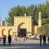
Kashgar Old City 喀什古城
A Silk Road crossroads of mud-brick lanes, bazaars and the Id Kah Mosque
Listed sites in Kashgar
20 sites in Kashgar are on the official lists. Those with a page of their own link to it; the rest open as cards on the map.
- Jinhuyang Desert Poplar Forest Park 金湖杨国家森林公园 5A scenic area · on the map
A forest park of desert poplars on the alluvial fan of the Yarkand River about 35 km south-west of Zepu, covering some 40,000 mu (about 27 km²), much of it natural poplar woodland, with water on three sides and the Kunlun range in the distance. - Tashkurgan Stone City (Pamir Scenic Area) 塔什库尔干石头城 5A scenic area · National heritage site
A 5A scenic area on the edge of Tashkurgan town built around the hilltop Stone City, the ruined walled town that was the seat of the Han-era kingdom of Puli and was greatly enlarged under the later kingdom of Qiepantuo, described by the monk Xuanzang on his way home from India. - Afaq Khoja Mausoleum 阿巴和加麻扎 4A scenic area · National heritage site
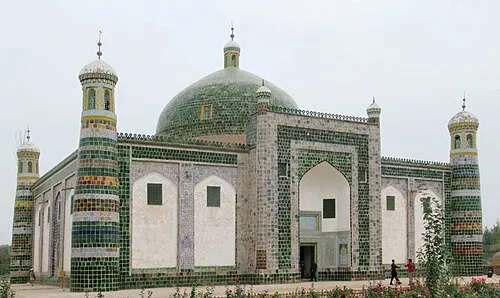
The family mausoleum of Afaq Khoja, a 17th-century Sufi leader of Kashgar, begun in 1640 for his father, and popularly called the Tomb of the Fragrant Concubine after the legend of the Qianlong Emperor's Uyghur consort. - Bachu Red Sea Scenic Area 巴楚红海 4A scenic area · on the map
A large leisure area 12 km from Bachu county town that links a folk-culture village, a stretch of the old Silk Road route along the Kashgar River, Golden Poplar Island in the desert-poplar woods, the Red Sea Bay water park and wetlands. - Dawakun Desert Scenic Area 达瓦昆沙漠 4A scenic area · on the map
A desert scenic area on the western edge of the Taklamakan beside the Yarkand River in Yopurga County, where a lake lies among the sand dunes beneath the distant Kunlun range. - Dolan Painters' Village 刀郎画乡 4A scenic area · on the map
A village of Dolan farmer painters in Kumkusar township just south of Markit, twice named a national folk-art village by the Ministry of Culture, whose painters have exhibited their work in China and abroad. - Jiashi Town Poplar Eco-Park 城中胡杨生态园 4A scenic area · on the map
An ecological park on the north-western side of Jiashi county town, opened in 2019 and planned over about 1,050 mu around a stand of desert poplars linked by waterways. - Khunjerab Pass National Gate 红其拉甫国门 4A scenic area
The national gate building at the Khunjerab Pass, where the Karakoram Highway (G314) reaches the border with Pakistan at about 4,700 m, on the only land crossing between the two countries. - Taklamakan N39° Desert Scenic Area 塔克拉玛干N39°沙漠 4A scenic area · on the map
A desert activity area among the Taklamakan dunes in Markit County, used for a stage of the Taklimakan Rally; its name refers to the 39th parallel north. - Why Are the Flowers So Red Scenic Area 花儿为什么这样红景区 4A scenic area · on the map
A long, narrow river valley south-east of Tashkurgan promoted as the home of 'Why Are the Flowers So Red', the song from the 1963 film Visitors on the Icy Mountain that the composer Lei Zhenbang adapted from the Tajik folk song 'Guli Bita'. - Yarkand Old Town 莎车老城 4A scenic area · on the map
The historic quarter of Yarkand (Shache), once the capital of the Yarkand Khanate, rated as a 4A scenic area in 2022. - Yengisar South Lake Resort 英吉沙南湖 4A scenic area · on the map
A lakeside resort along the dam of a reservoir 5.5 km south of Yengisar town, inside a national wetland park. - Zhang Qian Silk Road Cultural Park 张骞丝路文化园 4A scenic area · on the map
A park in Shule county town dedicated to Zhang Qian, the Han dynasty envoy to the Western Regions, centred on the Han-style Zhang Qian Memorial Hall and Shule Museum opened in 2010. - Zonglang Spring 宗郎灵泉 4A scenic area · on the map
A spring oasis at the foot of the Kunlun Mountains, where water trickles from cracks in a cliff above the east bank of the Ulukustang River into a round pool about 10 m across, shaded by four ancient willows. - Jame Mosque, Yarkand 莎车加满清真寺 National heritage site · on the map
The oldest and largest mosque in Yarkand, whose founding is dated variously from 1409 to the 17th century, when it was enlarged and named Jame under Abdullah Khan, and which was repaired several times in later centuries. - Jirzankal Cemetery 吉尔赞喀勒墓地 National heritage site · on the map
A cemetery of around 500 BC on terraces above the Tashkurgan River, where low round burial mounds lie beside long stripes of alternating black and white pebbles laid across the gravel ground. - Mor Buddhist Temple Ruins 莫尔寺遗址 National heritage site · on the map
The ruins of the largest known Buddhist monastery around Kashgar, where two mud-brick stupas, one round with a domed top and one stepped and square, still stand on a gravel terrace. - Princess Castle 公主堡 National heritage site · on the map
The ruins of a fortress dated to the Tang dynasty, listed as the Gongzhubao ancient city site, about 70 km by road south of Tashkurgan near the Kalachigu valley. - Tomb of Mahmud al-Kashgari 麻赫穆德·喀什噶里墓 National heritage site · on the map
The tomb of Mahmud al-Kashgari, the 11th-century scholar who compiled the Dīwān Lughāt al-Turk, a dictionary of the Turkic languages, in Baghdad in the 1070s; local tradition holds that he was born at Opal and returned there to teach. - Yarkand Khanate Royal Tombs 叶尔羌汗国王陵 National heritage site
The burial ground of the khans of the Yarkand Khanate, which ruled from Yarkand in the 16th and 17th centuries, lying behind the Altyn Mosque in the old town.
Getting to Kashgar
Train, flight and driving times from the cities most visitors come from, with stations, fares and how many run a day; each opens the full comparison.
- Ürümqi 乌鲁木齐 train 11 h 30 min, 9 a day, from ¥305; 15 nonstop flights a day, 2 h 10 min in the air
Trips with Kashgar
- Xinjiang: Ürümqi, Turpan, Kashgar, Karakul Lake and Kanas 11 days · Ürümqi, Turpan, Kashgar and Burqin
On the map
Open Kashgar on the illustrated map to see its outline, its places and listed sites together, and to add them to a trip.
Open Kashgar on the map