 Atlas of China
Qujing 曲靖Qǔjìng
Golden rapeseed, 1,600-year-old calligraphy and one of China's great hams
About Qujing
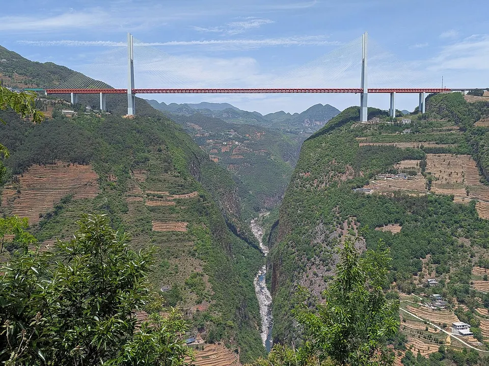
Qujing guards the main road in from Guizhou, and old nicknames called it the 'throat of Yunnan'. Now an industrial city 45 minutes from Kunming by high-speed train, it is visited above all for the Luoping Rapeseed Fields, which turn gold around conical karst hills in late winter. Calligraphers prize its 5th-century Cuan steles, Xuanwei cures one of China's three famous hams, and the Duge Bridge over the Nizhu River gorge was the world's highest bridge from 2016 to 2025.
What to eat in Qujing
- Xuanwei ham (宣威火腿)
- Steamed rice-cake noodles (蒸饵丝)
Featured places in Qujing
-
Luoping Rapeseed Fields 罗平油菜花海
Seas of golden rapeseed flowers swirling around karst peaks and spiral terraces
Listed sites in Qujing
11 sites in Qujing are on the official lists. Those with a page of their own link to it; the rest open as cards on the map.
- Coloured Sand Forest, Luliang 彩色沙林 4A scenic area · on the map
At the foot of Wufeng Mountain south of Luliang town, the Coloured Sand Forest is about 6 square kilometres of weathered sandstone eroded into ridges, pinnacles and gullies in shades of red, yellow, white and grey. - Dahai Grassland Mountain 大海草山 4A scenic area · on the map
Dahai Caoshan ('Dahai grass mountain') is an expanse of high, open grassland in the Wumeng Mountains, in Dahai township south of Huize, ranging from about 2,570 m to 4,017 m. - Duoyi River 多依河 4A scenic area · on the map
The Duoyi River flows through Lubuge township in south-eastern Luoping near the Guizhou border, dropping over dozens of small waterfalls between banks lined with old trees and bamboo. - Nizhu River Grand Canyon 尼珠河大峡谷 4A scenic area · on the map
The Nizhu River, the lower course of the Kedu River and a tributary of the Beipan, has cut a deep gorge along the Yunnan–Guizhou border in Puli township, Xuanwei. - Source of the Pearl River 珠江源 4A scenic area · on the map
The Pearl River is held to rise on Maxiong Mountain in Zhanyi, whose eastern slopes became a national forest park of about 12.5 square kilometres in 1993. - Yulu Earth Crack 雨碌大地缝 4A scenic area · on the map
The Yulu 'Earth Crack' is a narrow karst slot gorge in Yulu township, south-east of Huize. - Cuan Baozi Stele 爨宝子碑 National heritage site
Carved in AD 405, the Cuan Baozi Stele is the 1.83 m tombstone of Cuan Baozi, a local governor of the powerful Cuan clan, and its 403 characters are a celebrated example of calligraphy caught between clerical and regular script. - Cuan Longyan Stele 爨龙颜碑 National heritage site
Erected in 458, the Cuan Longyan Stele is the 3.38 m memorial stone of Cuan Longyan, a regional governor from the Cuan clan that dominated eastern Yunnan for centuries. - Dajue Temple, Luliang 大觉寺 National heritage site · on the map
Dajue Temple in the old centre of Luliang is a Buddhist temple whose listed buildings date from the Yuan and Ming dynasties. - Huize Guild Halls 会泽会馆 National heritage site
Huize's old town keeps a group of Qing-dynasty guild halls, the 'eight great halls' built by merchant and migrant communities, mostly from other provinces, among them those of Jiangxi, Huguang, Guizhou, Fujian, Shaanxi and Sichuan. - Kedu Pass Post Road 可渡关驿道 National heritage site · on the map
At Kedu Pass, where the Kedu River marks the border between Yunnan and Guizhou, an old post road about 5 km long and 2 m wide survives beside Kedu village.
On the map
Open Qujing on the illustrated map to see its outline, its places and listed sites together, and to add them to a trip.
Open Qujing on the map