
 An illustrated travel map
Kalajun Grassland 喀拉峻草原Kālājùn Cǎoyuán
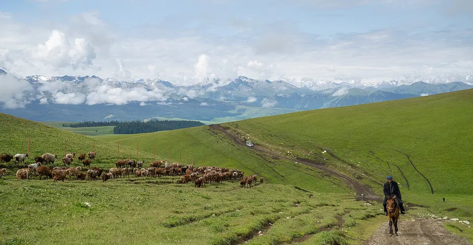
Rolling alpine meadows, flower terraces and snow peaks above Tekes
- Best time
- Jun–Aug
- Time needed
- 1–2 days
- Days to budget
- 1½ days
- Stay in
- Ili
- Region
- Xinjiang
- Type
- Nature
- Listed as
- 5A scenic area, UNESCO World Heritage
Why go to Kalajun Grassland
A great sweep of alpine meadow on the northern slopes of the Tianshan in Tekes County, ranging from about 1,300 m to nearly 4,000 m and used as summer pasture by herders. It forms part of the Kalajun–Kuerdening component of the Xinjiang Tianshan World Natural Heritage site. West Kalajun is known for wave-like rolling hills and marmot habitat; East Kalajun for flower meadows, a forested canyon and views of snow peaks.
The story
The meadows have long served as summer pasture for herders, and the area was inscribed in 2013 as the Kalajun–Kuerdening component of the Xinjiang Tianshan, where two protected areas were merged into one.
What to see at Kalajun Grassland
- West Kalajun 西喀拉峻: The wave-like rolling hills and open meadow of the western section, with marmot habitat and sweeping views toward the snow peaks.
- Flower Terrace 鲜花台: A meadow viewpoint in East Kalajun, at its best from late spring into summer when wildflowers cover the slopes.
- Kurdai forest canyon 库尔代森林大峡谷: A forested canyon in the eastern section, one of the stops on the eastern route.
- Falcon Terrace 猎鹰台: An outlook where grassland, canyon and snow peaks come into one view; reached on foot from the Flower Terrace.
How to visit Kalajun Grassland
Take the scenic-area shuttle from the entrance; East and West Kalajun are separate sections some distance apart. West Kalajun is the easier first day, with the rolling hills reached by short walks from the stops. East Kalajun runs from the Wanna station to the Flower Terrace and the Falcon Terrace, and the walk between those two is long, several kilometres. A single day covers one section; a second day lets you do both.
How to get to Kalajun Grassland
The scenic area lies south-east of Tekes town, roughly half an hour to an hour by road depending on the section. Private cars cannot drive into the scenic areas; you move around by shuttle bus.
Where to stay
Tekes town is the usual base, with a range of hotels and guesthouses about half an hour from the entrance and an octagonal street layout worth a stroll. Some yurt and camp stays operate on the grassland itself.
What to eat
- Narin 纳仁: A Kazakh dish of hand-cut noodles in lamb broth, topped with meat.
- Hand-grabbed lamb 手抓肉: Boiled lamb on the bone, found in yurt camps and restaurants in Tekes.
- Baursak 包尔萨克: Small pieces of fried dough served with tea, a staple of Kazakh hospitality.
Tips for visiting Kalajun Grassland
- Wildflowers on the Flower Terrace are densest from May to July; weather changes fast and nights are cold, so bring layers and rain protection. Check official notices as some lines and viewpoints may close in bad weather.
- East and West Kalajun, and the nearby Kuoksu canyon, are separate sections with their own ticketing and shuttle arrangements that change from year to year; the area has no official website of its own, so check with the Tekes tourism authority and carry your passport.
- Some viewpoints lie a half-hour or more on foot from the shuttle stops, so wear sturdy shoes and bring water.
Nearby
Also within 30 km: Tekes Bagua City 特克斯八卦城 (10 km), Aktas Girl Peak 阿克塔斯姑娘峰 (30 km).
On the map
Open Kalajun Grassland on the illustrated map to see the terrain around it, what else is close, and to add it to a trip and plan the days.
Open Kalajun Grassland on the map