 Atlas of China
Ili 伊犁Yīlí
Summer pastures, lavender fields and Xibe towns in a green valley
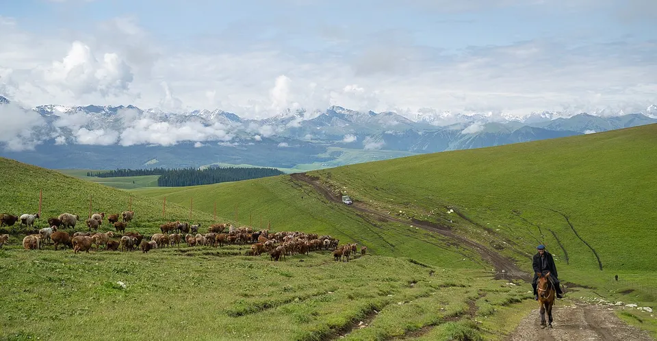
- Type
- Kazakh Autonomous Prefecture
- Region
- Xinjiang
- Seat
- Yining
- Featured places
- 1
- Listed sites
- 401 rated 5A · 27 rated 4A · 14 national heritage
About Ili
The Ili valley opens west towards Kazakhstan between ranges of the Tian Shan, and its slopes carry grassland, spruce forest and woods of wild fruit and walnut; herders still take their flocks up to the summer pastures of Nalati and Kalajun. Yining, the capital, has a blue-and-white old town and the star-shaped Liuxing Street, and Huocheng's lavender fields flower in June. Qapqal is home to the Xibe, sent from Manchuria to garrison Ili in 1764, and Zhaosu, home of the Shengyou Temple, breeds Ili horses.
Featured places in Ili
-
Nalati Grassland 那拉提草原
A green plateau meadow where Kazakh herders ride beneath spruce slopes
Listed sites in Ili
40 sites in Ili are on the official lists. Those with a page of their own link to it; the rest open as cards on the map.
- Kalajun Grassland 喀拉峻草原 5A scenic area · on the map
A great sweep of alpine meadow on the northern slopes of the Tianshan in Tekes County, ranging from about 1,300 m to nearly 4,000 m and used as summer pasture by herders. - Aktas Girl Peak 阿克塔斯姑娘峰 4A scenic area · on the map
Upland grassland on the Aktas pastures north-west of Tekes, a 'sky grassland' of flower meadows in early summer, with primulas and globeflowers, and forest edges below snow peaks. - Daxigou Fushou Mountain 中华福寿山 4A scenic area · on the map
Hills of wild fruit forest in Daxigou township, Huocheng County, where some 60 kinds of wild fruit tree grow, mainly wild apple, wild cherry plum, apricot and hawthorn; the wild cherry plum here is its only natural population in China. - Dengta Educated Youth Museum 灯塔知青馆 4A scenic area · on the map
A museum opened in 2014 at the former Dengta pasture near Zhaosu, where more than 80 educated youths from Beijing and Shanghai were sent to live and work in the 1970s under the 'up to the mountains and down to the countryside' movement. - Gongliu Wild Walnut Valley 野核桃沟 4A scenic area · on the map
A valley in the hills near Gongliu town that shelters a rare natural stand of wild walnut trees, a relict species from the Tertiary period, within a scenic area of about 12 km². - Guozigou Valley 果子沟 4A scenic area · on the map
A winding gorge about 32 km long through the northern Tianshan, named for the wild fruit forests on its slopes and long the main route from Sayram Lake down into the Ili valley, once a branch of the northern Silk Road. - Huiyuan Ancient City 惠远古城 4A scenic area · National heritage site · on the map
Huiyuan was founded in 1763 as the seat of the Qing General of Ili, the highest military and civil official in Xinjiang, and remained the region's chief city until Xinjiang became a province; after the old city was ruined in the 1860s and 1870s, a new town was built in 1882–93 about 7.5 km to the north. - Ili Kazakh Autonomous Prefecture Museum 伊犁州博物馆 4A scenic area · on the map
The prefecture's main museum, founded in 1993 and now housed in a large new building on Ruyi Street in western Yining. - Ili Old Town (Kazanqi) 伊犁老城 4A scenic area · on the map
The old quarter of Yining, about 3.5 km² of lanes with more than 300 traditional buildings and many courtyard houses in blue and white, where about 120,000 people still live. - Ili River Scenic Area 伊犁河风景区 4A scenic area · on the map
A riverside park along the Ili River on the southern edge of Yining, popular with locals on summer evenings and for watching the sunset over the water. - Jinxiu Garden, Kuytun 锦绣园 4A scenic area · on the map
A landscaped park in the city of Kuytun, developed around the North Xinjiang Botanical Garden and used by local people for walks and open-air performances. - Khorgos China–Kazakhstan International Cultural Tourism Area 霍尔果斯中哈国际文化旅游区 4A scenic area · on the map
A tourist zone at the Khorgos land port made up of the Chinese part of the China–Kazakhstan Horgos International Border Cooperation Centre, a cross-border trade zone set up under a 2005 agreement, and the National Gate area with an exhibition hall on the history of the crossing. - Kurdening Scenic Area 库尔德宁 4A scenic area · on the map
A broad valley on the northern side of the Tianshan in Gongliu County, unusual for running north to south and filled with primeval forest of Schrenk's spruce, part of the Xinjiang Tianshan World Natural Heritage site. - Liuxing Street 六星街 4A scenic area · on the map
A residential quarter of Yining laid out from 1935 on a six-pointed street plan, with lanes radiating from a central square through six wedge-shaped blocks of blue, green, orange and purple-painted houses and courtyards. - Nalati National Wetland Park 那拉提国家湿地公园 4A scenic area · on the map
Reed beds, rivers, marshes and lakes in Xiaoerbulake town, Xinyuan County, a national wetland park since 2019 on a migration route for birds. - Nilka Wetland Ancient Poplar Forest 湿地古杨 4A scenic area · on the map
Riverside woodland of old poplars and Tianshan birch along the Kash River just west of Nilka town, part of a belt of poplar forest that follows the river for about 110 km and a national wetland park since 2014. - Princess Jieyou Lavender Garden 解忧公主薰衣草园 4A scenic area · on the map
A lavender park in Qingshuihe town, Huocheng County, set up to show the whole lavender industry, from nurseries and fields to oil distilling and product displays. - Tangbula Grassland 唐布拉草原 4A scenic area · on the map
A chain of grassland, spruce forest and hot springs strung along the upper Kash River valley for more than 50 km in eastern Nilka County, often called the 'hundred-li gallery'. - Tekes Bagua City 特克斯八卦城 4A scenic area · on the map
The county town of Tekes, laid out on a radial plan modelled on the eight trigrams (bagua) of the Book of Changes: from the Taiji altar at the centre, streets run outwards across four ring roads, 64 streets in all over about 8 km². - Tianshan Flower Sea 天山花海 4A scenic area · on the map
An agri-tourism park developed since 2017 on former gravel desert in Kashi town, Yining County, covering about 46 km² of lavender, flower fields and orchards. - Tukai Desert 图开沙漠 4A scenic area · on the map
An area of mostly fixed and semi-fixed sand dunes beside the Ili River south-west of Huocheng town, described locally as the only desert inside an oasis in Xinjiang. - Tuohulasu Grassland 托乎拉苏草原 4A scenic area · on the map
Rolling hill grassland on the southern side of the Keguqin range of the western Tianshan, north of Yining County town, with spruce, streams and summer herds below snow peaks. - Xiaoerbulake Liquor Culture Town 肖尔布拉克酒文化小镇 4A scenic area · on the map
A distillery town in Xinyuan County built around a large baijiu works, where visitors can see the Western Regions Liquor Culture Museum, a liquor street, a sauce-aroma baijiu workshop and a yard of decorated earthenware storage jars. - Xiata Scenic Area 夏塔 4A scenic area · on the map
The mouth of the Xiata valley on the north side of the Tianshan, with spruce forest, meadows and river valleys below the Muzart glacier and snow peaks. - Xibe Ancient City and Jingyuan Temple 锡伯古城与靖远寺 4A scenic area · National heritage site · on the map
A modern tourist town in old style in Sunzhaqi Niru, a Xibe village outside Qapqal town, built around Jingyuan Temple, the Tibetan Buddhist (Gelug) temple of the Qing Xibe garrison, whose halls were rebuilt in the late 19th century on a Chinese plan with a Hall of the Heavenly Kings, a main hall and side halls. - Zhaosu Celestial Horse Culture Park 天马旅游文化园 4A scenic area · on the map
An equestrian park at the Zhaosu horse farm, in the heartland of Ili horse breeding, with a national-standard racecourse, grandstands, an indoor equestrian hall and stables. - Zhaosu Jade Lake 昭苏玉湖 4A scenic area · on the map
A glacier-fed lake dammed high in the Aheyazi valley of the Tianshan, whose milky blue-green colour, given by fine rock flour from the glaciers, shifts with the light. - Zhaosu Wetland Park 昭苏湿地公园 4A scenic area · on the map
Wetland and meadow along the upper Tekes River and its tributaries south of Zhaosu town, where some 90 bird species have been recorded, including demoiselle and common cranes, whooper swans and great bustards. - Baitulla Mosque Minaret 拜吐拉清真寺宣礼塔 National heritage site · on the map
The Qing-era minaret of Yining's Baitulla Mosque (now the Jiefang South Road Mosque), completed in 1773 with Qing court funds and built by craftsmen from inner China. - Former Political and Cultural Centre of the Three Districts Revolutionary Government 三区革命政府政治文化活动中心旧址 National heritage site · on the map
A reviewing stand, open-air theatre and stage completed in 1949 as the main gathering place of the Three Districts (Ili, Tacheng and Altay) during the Three Districts Revolution of 1944–49, now in Yining's People's Park. - Gedeng Mountain Stele 格登碑 National heritage site
A stone stele with an inscription composed by the Qianlong Emperor to mark the Qing army's victory over the Dzungar ruler Dawachi at Gedeng Mountain in 1755, set up on the hilltop in the early 1760s. - Guandi Temple of Nadaqi Niru 纳达齐牛录关帝庙 National heritage site · on the map
A temple to the warrior god Guan Yu built in 1907 by the Xibe garrison of the seventh banner company (niru), whose ancestors were moved from Manchuria to guard Ili in 1764; it is the largest and best-preserved Qing Guandi temple left in Qapqal County. - Mausoleum of Sultan Vais Khan 速檀·歪思汗麻扎 National heritage site · on the map
The tomb of Vais Khan, a 15th-century ruler of the Eastern Chagatai Khanate (Moghulistan), on the north side of the Abrel hills in Yining County. - Nulasai Ancient Copper Mine 奴拉赛铜矿遗址 National heritage site · on the map
Remains of a copper mine and smelting site in the Nulasai ravine of the Abrel hills south of Nilka, dated by radiocarbon from mine timbers to about 2,400 years ago, around the early Warring States period. - Qing-dynasty Karun Sites of Ili 伊犁清代卡伦遗址 National heritage site · on the map
Sixteen surviving guard posts (karun, from the Manchu and Xibe word for a watch post) of the late Qing defence system around Ili, once manned by Manchu, Han and Xibe troops. - Shaanxi Great Mosque, Yining 伊宁陕西大寺 National heritage site
The largest mosque among the nine Qing-era towns of Ili, founded in the mid-18th century by Hui settlers from Shaanxi and Gansu and brought to its present size by 1781. - Shengyou Temple, Zhaosu 昭苏圣佑庙 National heritage site · on the map
A Tibetan Buddhist (Gelug) temple built in 1884–98 by the Oirat Mongols of Ili with craftsmen brought from Beijing, described as the largest and best-preserved Tibetan Buddhist temple complex in Xinjiang. - Tughlugh Timur Mausoleum 吐虎鲁克·铁木尔汗麻扎 National heritage site
The tomb of Tughlugh Timur, a descendant of Chinggis Khan's son Chagatai and the first Mongol khan in the region to adopt Islam, built between 1363 and 1369 north-east of Huocheng. - Xiaohongnahai Stone Figure 小洪纳海石人墓 National heritage site · on the map
A warrior statue of reddish granite, about 1.8 m tall above ground, standing on a low earthen platform and carved for the tomb enclosure of a ruler of the Western Turkic Khaganate around 600 AD, most likely Nili Khagan. - Xiata Ancient City Ruins 夏塔古城遗址 National heritage site · on the map
Ruins of a walled town of the Tang to Yuan periods in Kuositobie village, Xiate township, on the approach to the Xiata ancient road over the Tianshan.
On the map
Open Ili on the illustrated map to see its outline, its places and listed sites together, and to add them to a trip.
Open Ili on the map