 Atlas of China
Nanning 南宁Nánníng
A leafy capital of Zhuang folk song, jasmine tea and sour-spicy noodles
About Nanning
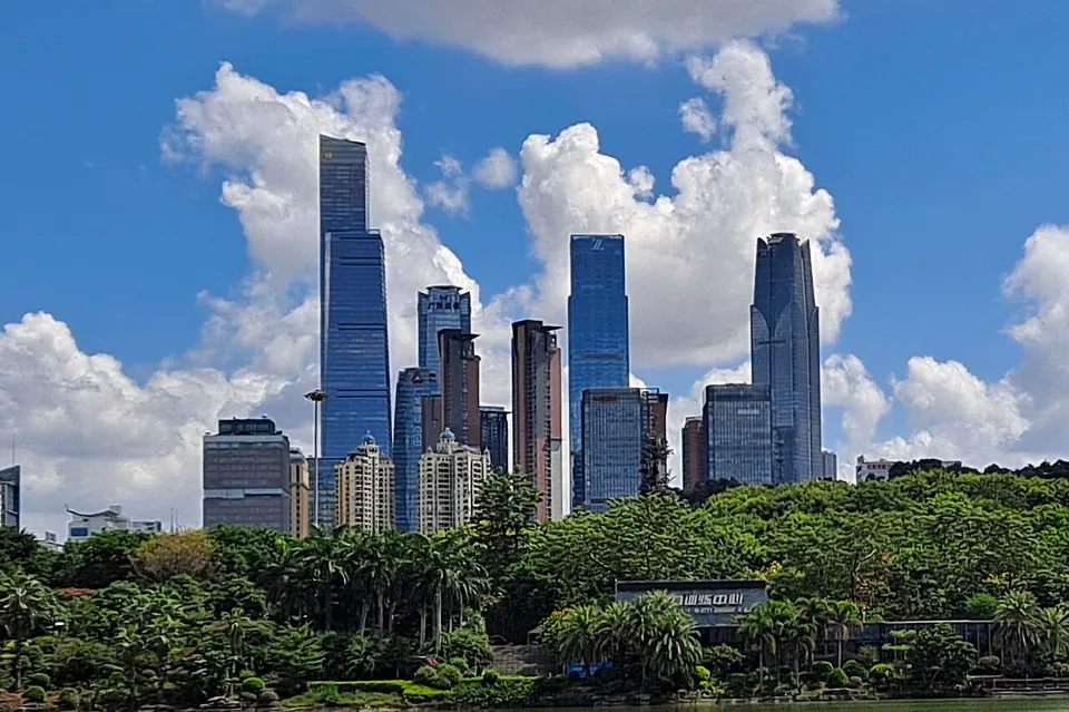
Guangxi's capital is known as the Green City for the subtropical trees and parks along the Yong River, and each autumn it hosts the China–ASEAN Expo, with exhibitors from across Southeast Asia. Qingxiu Mountain's wooded hills rise beside the river, and the Guangxi Museum of Nationalities introduces the Zhuang and the region's other peoples. Trips out of town lead to Yiling Cave, the Kunlun Pass battlefield and Hengzhou, which produces most of China's jasmine tea.
What to eat in Nanning
- Laoyou rice noodles (老友粉)
- Lemon duck (柠檬鸭)
Listed sites in Nanning
50 listed sites are in Nanning. These are the 47 rated 5A or 4A; see all 50 in the Guangxi list.
- Qingxiu Mountain 青秀山 5A scenic area
A hilly park of 18 low ridges on the north bank of the Yong River in south-eastern Nanning, developed from a former forest farm since 1984, whose highest point rises to 289 m. - Bagui Tianyuan Agricultural Park 八桂田园 4A scenic area · on the map
A modern agriculture showcase set up in 1999 by the Guangxi Department of Agriculture on the training farm of the provincial agricultural school and now run under Guangxi Agricultural Vocational University. - Baiyi Shanghe City 百益·上河城 4A scenic area · on the map
A creative and leisure district in the red-brick workshops of the former Nanning silk-spinning mill, built in 1966, south of the Yong River in Jiangnan District, converted and opened in 2018. - China Jasmine Garden, Hengzhou 中华茉莉园 4A scenic area · on the map
A jasmine park of variety gardens, a wetland lake and wide flower fields around Shijing village in Xiaoyi town, at the centre of Hengzhou's jasmine industry, which produces more than 80 per cent of China's jasmine flowers and jasmine tea. - Dalong Lake 大龙湖 4A scenic area · on the map
A reservoir lake in the karst hills of Xiyan town in northern Shanglin County, formed in 1958 by damming underground water, which now covers about 560 hectares with 14 small islands and 16 caves. - Damiaojiang Eco-Tourism Area 大庙江 4A scenic area · on the map
An outdoor recreation area of about 630 hectares at the foot of the Daming Mountains nature reserve in Shanglin County, built around a forest rafting run on the Damiao River. - Daming Mountain 大明山 4A scenic area · on the map
A mountain range in central Guangxi, about 68 km long and spanning Wuming, Shanglin, Mashan and Binyang, whose main peak, Longtou Shan, reaches 1,760 m, the highest in central-southern Guangxi, and which the Tropic of Cancer crosses. - Dingsishan Neolithic Site 顶蛳山遗址 4A scenic area · National heritage site · on the map
A freshwater shell-midden site on a terrace where the Bachi River meets a stream, lived on from about 10,000 to 6,000 years ago and excavated between 1997 and 2000, when 331 burials, many of them tightly flexed, were found; it gave its name to the Dingsishan culture, the first Neolithic culture defined in Guangxi. - Dream Town (Mengxiangcheng) 梦想城 4A scenic area · on the map
A modern resort area built in imitation of the Austrian lakeside village of Hallstatt, set by a lake among karst peaks near Yiling Cave in Shuangqiao town. - Fengling Children's Park 凤岭儿童公园 4A scenic area · on the map
A children's park of about 56 hectares laid out over hilly ground in the Fengling district of eastern Nanning, opened on 1 June 2012. - Flower World of Nanning 花花大世界 4A scenic area · on the map
A flower-themed leisure park of about 113 hectares in Shuangqiao town, Wuming, with seasonal flower fields, bougainvillea gardens, a large lawn, lotus ponds crossed by a Zhuang-style covered bridge and a hilltop walkway with a glass section. - Golden Camellia Park 金花茶公园 4A scenic area · on the map
A city park on the west side of Nanhu Lake devoted to golden camellias, rare yellow-flowered camellias under national protection, with a gene bank that collects and studies many kinds of them alongside other camellias and tea plants. - Guangxi Botanical Garden of Medicinal Plants 广西药用植物园 4A scenic area · on the map
A research botanical garden founded in 1959 on 202 hectares of low hills on the north-eastern edge of Nanning, which conserves more than 10,000 species of medicinal plants and was certified by Guinness World Records in 2011 as the largest medicinal botanical garden. - Guangxi Gaofeng Forest Park 广西高峰森林公园 4A scenic area · on the map
A forest park run by the state-owned Gaofeng Forest Farm in the hills on Nanning's northern edge, with a core area of about 1,200 hectares and around 90 per cent forest cover. - Guangxi Museum of Nationalities 广西民族博物馆 4A scenic area
A museum of the cultures of Guangxi's 12 long-established ethnic groups beside the Yong River within the Qingxiu Mountain scenic area, completed in December 2008 and opened to the public in May 2009, in a main building whose shape is taken from a bronze drum. - Guangxi Planning Exhibition Hall 广西规划馆 4A scenic area · on the map
A large exhibition hall in the Wuxiang New Area, opened on 8 November 2011, presenting Guangxi's development and its urban and regional planning in about 46,000 m² of floor space. - Guangxi Science and Technology Museum 广西科技馆 4A scenic area · on the map
Guangxi's main science museum, founded in 1983 and moved into a new building near Minzu Square in December 2008, with about 9,000 m² of permanent exhibitions on engineering, information technology and bioengineering. - Guangxi Zhuang Autonomous Region Museum 广西壮族自治区博物馆 4A scenic area
Guangxi's main history museum, founded in 1934 and a national first-grade museum, which reopened on Minzu Square in November 2022 after more than four years of rebuilding that doubled its floor space and enlarged its galleries to about 10,000 m². - Gula Daohuaxiangli (Cai Family Mansion) 古辣稻花香里 4A scenic area · on the map
A rural scenic area of about 72 hectares in Cai village near Gula town, built around the Cai family's old residential compound of more than 180 rooms, whose halls, courtyards and corner watchtowers date from rebuilding after 1859 in the late Qing dynasty. - Gumingzhai Zhuang Village 鼓鸣寨 4A scenic area · on the map
Guminzhuang, a Zhuang village developed as the Gumingzhai scenic area, lies beside a lake with small islands in a valley ringed by hills and has 158 rammed-earth houses, most of them built in the Qing and Republican periods. - Jiangnan Park, Nanning 江南公园 4A scenic area · on the map
A large city park south of the Yong River in Jiangnan District, opened in June 2018 and laid out around linked lakes with Wenfeng Hill as a backdrop. - Jiulong Waterfalls National Forest Park 九龙瀑布群 4A scenic area · on the map
A national forest park in the state-owned Zhenlong forest farm in the hills of northern Hengzhou, where streams drop through a cluster of waterfalls in tall forest below Jiulong Mountain. - Jiuquwan Hot Spring Resort 九曲湾温泉 4A scenic area · on the map
A hot-spring resort in Santang town on the north-eastern edge of Nanning, open since November 2005, with indoor and outdoor thermal pools and décor drawing on Zhuang and other ethnic cultures. - Kunlun Pass 昆仑关 4A scenic area · National heritage site · on the map
A mountain pass on the old road between Nanning and Liuzhou, first walled with stone in 816 and best known as the site of the Battle of Kunlun Pass in December 1939, when Chinese troops of the Fifth Army retook the pass from the Japanese army after about two weeks of fighting with heavy casualties on both sides. - Liangfengjiang National Forest Park 良凤江国家森林公园 4A scenic area · on the map
One of the earliest national forest parks approved by China's former Ministry of Forestry, on the south-western outskirts of Nanning along the Liangfeng River. - Longhu Mountain 龙虎山 4A scenic area · on the map
A nature reserve of forested limestone hills in Pingshan township, Long'an County, known as one of China's 'four great monkey mountains' for its more than 3,000 wild rhesus macaques. - Longmen Shuidu 龙门水都 4A scenic area · on the map
A leisure resort in forested hills around Longmen Reservoir on the north-western edge of Nanning, about 15 km from the city centre. - Minge Lake 民歌湖 4A scenic area · on the map
A landscaped lake park beside the Nanning International Convention and Exhibition Centre in Qingxiu District, with lakeside promenades, bars and restaurants, evening lights and sightseeing boats. - Mingshan Eco-Tourism Area 名山 4A scenic area · on the map
A hill area in Chenping town in southern Binyang County, made up of three peaks whose highest, Mingshan Top, rises to 876 m, the second-highest point in the county, above plum orchards and villages. - Nanguo Countryside 南国乡村 4A scenic area · on the map
A rural tourism area in Nagong hamlet, Sugong village, Shuangqiao town, built around a museum of rural house building that presents the village architecture of different ethnic groups alongside new building methods. - Nanning Culture, Tourism and Art Park 南宁文化旅游艺术园 4A scenic area · on the map
A 4A area created in 2023 by grouping four sites run by the Guangxi Tourism Group in the Wuxiang area south of the Yong River: the 'Guanglü Nanning Night' evening leisure district, the Guangxi Art Museum, Central Park and the 'Yunduoduo' young artists' camp. - Nanning Garden Expo Park 南宁园博园 4A scenic area · on the map
The 263-hectare site of the 12th China International Garden Expo, opened in December 2018 beside the Bachi River in Yongning District on the south-eastern edge of Nanning. - Nanning International Convention and Exhibition Centre 南宁国际会展中心 4A scenic area · on the map
The hillside convention centre on Minzu Avenue that is the permanent venue of the annual China–ASEAN Expo and one of Nanning's landmark buildings, whose 41-hectare grounds were rated a 4A scenic area in 2021. - Nanning Polar Ocean World 南宁极地海洋世界 4A scenic area · on the map
A large indoor aquarium in the Rongsheng Tianhe Haiyue City shopping complex in Jiangnan District, laid out in themed halls on ocean legends, the polar regions and marine life, with an animal-petting area for children. - Nanning Wanda Mall 南宁万达茂 4A scenic area · on the map
A large indoor shopping and entertainment complex opened in June 2017 in the Wuxiang New Area south of the Yong River, rated 4A in 2018 for its indoor attractions. - Nanning Zoo 南宁动物园 4A scenic area · on the map
Nanning's city zoo, opened in April 1975 among about 37 hectares of subtropical gardens on University East Road in the north-west of the city. - Nongla Scenic Area 弄拉 4A scenic area · on the map
A hamlet in the karst peak-cluster hills of Guling town, Mashan County, whose villagers replanted the limestone hills around it after they were stripped of trees in the 1950s, and which is often cited as a model for reversing rocky desertification. - People's Park, Nanning 人民公园 4A scenic area
A city park in central Nanning, also called White Dragon Park after its 7-hectare White Dragon Lake, which has a small island reached by two bridges. - Pujin Park 蒲津公园 4A scenic area · on the map
An open park laid out over three limestone hills, Jinzhen, Yinzhen and Gong'e, in the middle of Pumiao, the seat of Yongning District. - Scenic Yong River and Ancient Yongzhou 秀美邕江·邕州古韵 4A scenic area · on the map
A riverside scenic area of about 1.5 km² along the Yong River in central Nanning, from Yangguan Wharf to Lingtie Bridge, rated 4A in 2020, with sculptures on the city's history and legends, the Changyou Pavilion, arcades and remains of old city walls along the bank. - Shouchuang Children's Park 首创儿童乐园 4A scenic area · on the map
A children's play park attached to the Shouchuang (Capital) Outlets mall on Kunlun Avenue in north-eastern Nanning, rated 4A in November 2023. - Shuijin Shunzhuang Scenic Area 水锦·顺庄 4A scenic area · on the map
A canyon resort area in Leping village, Guling town, ringed by the Daming Mountains, where the Shuijin stream runs through a natural gorge about 10 km long with waterfalls, spring pools and cascades. - Wuxiang Lake Park 五象湖公园 4A scenic area · on the map
A 122-hectare park around five linked lakes in the Wuxiang New Area south of the Yong River, opened in August 2013 as the site of the third Guangxi Garden and Horticulture Expo. - Xiangxieli Nanguo Hot Spring Valley 香榭里南国温泉谷 4A scenic area · on the map
A hot-spring resort in the Jiahe City development on Kunlun Avenue in north-eastern Nanning, next to a golf course, also known as the Jiahe City Hot Spring Valley. - Xiaodubai Village 小都百 4A scenic area · on the map
A rural tourism village in Qiaolao village, Guling town, beside the Mashan–Shanglin road, rebuilt with white-walled, grey-tiled houses in local Zhuang style and known as the 'home of waterwheels' for the wheels along its streams. - Yiling Cave 伊岭岩 4A scenic area · on the map
A karst cave in Yiling village, Shuangqiao town, about 25 km north of central Nanning, whose Zhuang name means 'a cave as beautiful as a palace', with a 1,100 m route through 24,000 m² of chambers full of stalactites, stalagmites, columns and flowstone. - Yongzhou Old Town (Sanjie Liangxiang) 邕州古城 4A scenic area · on the map
The old commercial heart of Nanning near the Yong River, centred on the Sanjie Liangxiang historic district of three old streets (Xingning, Minsheng and Jiefang roads) and two Ming–Qing lanes (Jinshi and Yinshi), whose history goes back to the Song dynasty.
Getting to Nanning
Train, flight and driving times from the cities most visitors come from, with stations, fares and how many run a day; each opens the full comparison.
On the map
Open Nanning on the illustrated map to see its outline, its places and listed sites together, and to add them to a trip.
Open Nanning on the map