 Atlas of China
China's physical geography in five minutes
China's land falls from west to east in three steps: the Tibetan Plateau averages over 4,000 m, the plateaus and basins of the middle step sit at 1,000 to 2,000 m, and the plains of the east lie below 500 m. Two great rivers cross those steps, the Yangtze (6,300 km) and the Yellow River (5,464 km). The highest point is Mount Everest at 8,849 m, the lowest the Aydingkol Lake depression at 154 m below the sea.
- Highest point
- Mount Everest8,849 m, Tibet–Nepal border
- Lowest point
- Aydingkol Lake-154 m, Turpan, Xinjiang
- Longest river
- Yangtze6,300 km
- Largest lake
- Qinghai Lake4,543 km², salt, 3,196 m up
- Largest desert
- Taklamakan337,000 km², Tarim Basin
- Largest plateau
- Tibetan Plateau2.5 million km², over 4,000 m
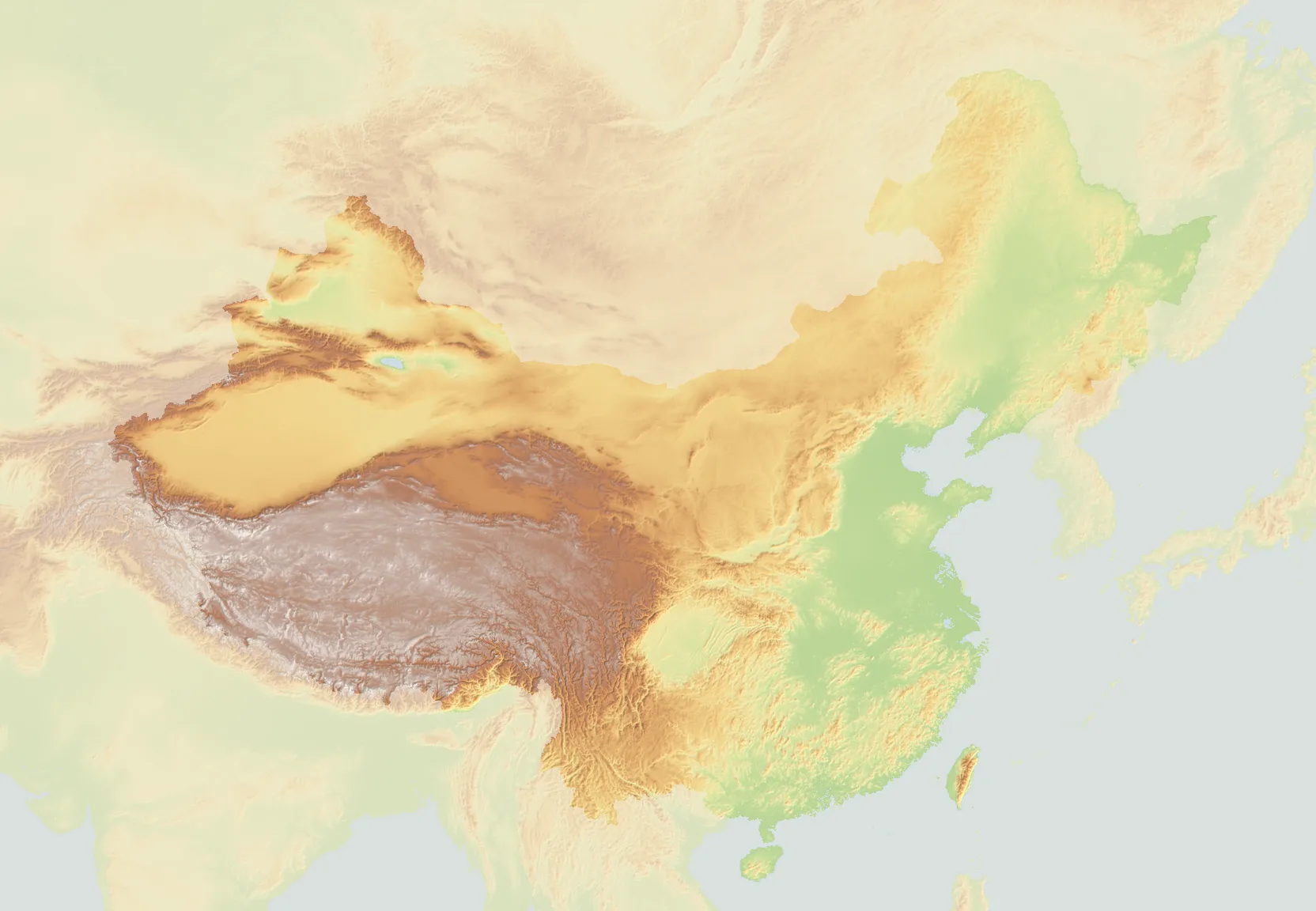
What are the three steps of China?
The land falls from west to east in three steps. The first is the Tibetan Plateau, averaging over 4,000 m, walled by the Himalaya, Karakoram and Kunlun. The second, at 1,000 to 2,000 m, is the plateaus and basins of the north and west: the Tarim and Junggar basins, the Inner Mongolian and Loess plateaus, the Sichuan Basin and the Yunnan–Guizhou Plateau. The third, below 500 m, is the plains of the east, the Northeast, North China and Yangtze plains, and the hills of the south-east, where most people live.
The step edges are the mountain lines on the map: the Kunlun, Qilian and Hengduan ranges hold the plateau up along the first edge; the Greater Khingan, Taihang, Wushan and Xuefeng ranges mark the second, where the Yangtze cuts through the Three Gorges. Tibet and Qinghai are the plateau; Xinjiang, Inner Mongolia, Gansu, Shaanxi, Sichuan, Yunnan and Guizhou are the middle step; the coast from Heilongjiang to Guangdong is the third.
Which are the longest rivers in China?
| River | Length | From | To | Notes |
|---|---|---|---|---|
| Yangtze长江 | 6,300 km | Tanggula Mountains, Qinghai | East China Sea at Shanghai | The longest river in Asia and the third in the world; Three Gorges Dam and the Three Gorges Dam are on its middle course. |
| Yellow River黄河 | 5,464 km | Bayan Har Mountains, Qinghai | Bohai Sea, Shandong | Carries the loess silt that named it; its lower bed runs above the surrounding plain between levees. |
| Heilongjiang (Amur)黑龙江 | 2,824 km | Argun and Shilka confluence | Sea of Okhotsk | The border with Russia for most of its length; 2,824 km as the Amur, 4,440 km with the Argun headwaters. |
| Pearl River (Xi)珠江 | 2,320 km | Yunnan–Guizhou Plateau | South China Sea at Guangzhou | The Xi, Bei and Dong rivers meet in the Pearl River Delta, the most crowded piece of China. |
| Tarim塔里木河 | 2,179 km | Pamir and Karakoram glaciers | Taitema Lake, Xinjiang | The longest inland river in China, ringing the Taklamakan and never reaching the sea. |
| Lancang (Mekong)澜沧江 | 2,139 km | Tanggula Mountains | South China Sea in Vietnam | Leaves China as the Mekong; 2,139 km of its 4,900 km are in China. |
| Yarlung Tsangpo (Brahmaputra)雅鲁藏布江 | 2,057 km | Angsi Glacier, Tibet | Bay of Bengal as the Brahmaputra | Turns south round Namcha Barwa through the deepest canyon on Earth. |
| Nu (Salween)怒江 | 2,020 km | Tanggula Mountains | Andaman Sea as the Salween | Runs parallel to the Lancang and the Jinsha in the Three Parallel Rivers, a World Heritage site. |
| Songhua松花江 | 1,897 km | Changbai Mountains | Heilongjiang at Tongjiang | The river of Harbin and Jilin; frozen for five months a year. |
| Liao辽河 | 1,345 km | Hebei and Inner Mongolia | Bohai Sea | Drains the Northeast Plain south of Shenyang. |
Three of these, the Yangtze, the Yellow and the Lancang, rise within 300 km of one another on the plateau in Qinghai, the Sanjiangyuan, "source of three rivers". Lengths are the usual published figures; where a river crosses a border the figure is the whole river unless the note says otherwise.
What are the highest mountains in China?
| Peak | Height | Range | Where |
|---|---|---|---|
| Mount Everest Qomolangma珠穆朗玛峰 | 8,849 m | Himalaya | Tibet, on the border with Nepal |
| K2 Qogir乔戈里峰 | 8,611 m | Karakoram | Xinjiang, on the border with Pakistan |
| Lhotse洛子峰 | 8,516 m | Himalaya | Tibet, on the border with Nepal |
| Makalu马卡鲁峰 | 8,485 m | Himalaya | Tibet, on the border with Nepal |
| Cho Oyu卓奥友峰 | 8,188 m | Himalaya | Tibet, on the border with Nepal |
| Gasherbrum I加舒尔布鲁木I峰 | 8,080 m | Karakoram | Xinjiang, on the border with Pakistan |
| Broad Peak布洛阿特峰 | 8,051 m | Karakoram | Xinjiang, on the border with Pakistan |
| Gasherbrum II加舒尔布鲁木II峰 | 8,034 m | Karakoram | Xinjiang, on the border with Pakistan |
| Shishapangma希夏邦马峰 | 8,027 m | Himalaya | Tibet; the only 8,000 m peak entirely within China |
| Namcha Barwa南迦巴瓦峰 | 7,782 m | Himalaya | Tibet, where the Yarlung Tsangpo turns south |
| Kongur Tagh公格尔峰 | 7,649 m | Pamir | Xinjiang, above the Karakoram Highway |
| Mount Gongga Minya Konka贡嘎山 | 7,556 m | Hengduan | Sichuan's highest, east of the Tibetan Plateau |
| Muztagh Ata慕士塔格峰 | 7,546 m | Pamir | Xinjiang, beside Karakul Lake |
| Tomur (Jengish Chokusu)托木尔峰 | 7,439 m | Tian Shan | the Tian Shan's highest, on the border with Kyrgyzstan |
| Ulugh Muztagh木孜塔格峰 | 6,973 m | Kunlun | the Kunlun's highest, between Xinjiang and Tibet |
| Kawagarbo Meili Snow Mountain卡瓦格博峰 | 6,740 m | Hengduan | Yunnan's highest, never climbed |
| Amne Machin阿尼玛卿山 | 6,282 m | Kunlun | Qinghai, by the upper Yellow River |
| Mount Siguniang四姑娘山 | 6,250 m | Qionglai | Sichuan, a day from Chengdu |
| Bogda Peak博格达峰 | 5,448 m | Tian Shan | Xinjiang, above Ürümqi and Tianchi lake |
| Friendship Peak友谊峰 | 4,374 m | Altai | where Xinjiang, Russia and Mongolia meet |
| Yushan Jade Mountain玉山 | 3,952 m | Yushan | Taiwan's highest; the highest point east of the Hengduan Mountains |
| Mount Emei峨眉山 | 3,099 m | Qionglai | Sichuan; one of the four sacred Buddhist mountains |
| Mount Wutai五台山 | 3,061 m | Taihang | Shanxi's highest; a sacred Buddhist mountain |
| Changbai Mountain Paektu长白山 | 2,744 m | Changbai | Jilin, on the border with North Korea; a crater lake at the top |
| Mount Hua华山 | 2,155 m | Qinling | Shaanxi; the western of the Five Great Mountains |
| Huangshan黄山 | 1,864 m | Huangshan | Anhui's highest; granite peaks above the clouds |
| Mount Tai泰山 | 1,545 m | Taishan | Shandong; the eastern of the Five Great Mountains |
Mount Everest (珠穆朗玛峰), 8,849 m, on the border between Tibet and Nepal. 9 of the world's fourteen peaks over 8,000 m stand in China or on its borders; Shishapangma (8,027 m) is the only one entirely within China. The sacred mountains of the east, Mount Tai, Mount Hua, Huangshan (Yellow Mountain) and Mount Wutai, are low by comparison, and climbed by far more people.
Where are the deserts, basins and plateaus?
- Tarim Basin and the Taklamakan, Xinjiang: a basin the size of Germany between the Tian Shan and the Kunlun, with China's largest desert in the middle and the Silk Road oases (Kashgar, Hotan, Kuqa) around its rim.
- Junggar Basin, north of the Tian Shan: the Gurbantünggüt desert, Ürümqi on its southern edge, and the Irtysh, China's only river to the Arctic, on its north.
- Gobi, Inner Mongolia and Gansu, shared with Mongolia: gravel plains more than sand, with the Badain Jaran's 400 m dunes in its west.
- Qaidam Basin, Qinghai: a salt basin at 2,700 m, the floor of the first step's north-east corner.
- Loess Plateau, Shaanxi, Shanxi and Gansu: 640,000 km² of wind-blown silt cut into ravines, the source of the Yellow River's colour and of the cave houses.
- Sichuan Basin, Sichuan and Chongqing: the "red basin" of purple sandstone, ringed by mountains, the most fertile land of the west, with Chengdu on its plain.
- Yunnan–Guizhou Plateau, Yunnan and Guizhou: limestone country at 1,000 to 2,000 m, with the karst towers of Shilin Stone Forest and, further east, Guilin.
- North China Plain: 310,000 km² of river silt from the Yellow, Huai and Hai rivers, flat from Beijing to the Yangtze, and the country's old heartland.
- Northeast Plain: the largest plain, between the Greater and Lesser Khingan and the Changbai Mountains, with black soil and the coldest winters.
Which are the biggest lakes?
| Lake | Area | Where | Notes |
|---|---|---|---|
| Qinghai Lake青海湖 | 4,543 km² | Qinghai, 3,196 m | The largest lake in China; salt water, ringed by a cycling road. |
| Poyang Lake鄱阳湖 | about 3,500 km² | Jiangxi | The largest freshwater lake, swelling in the summer floods and shrinking to channels in winter; wintering cranes. |
| Dongting Lake洞庭湖 | about 2,600 km² | Hunan | Once the largest, silted by the Yangtze; the dragon-boat race began here. |
| Siling Co色林错 | 2,391 km² | Tibet, 4,530 m | Now the largest lake in Tibet, grown a third since the 1970s with glacier melt. |
| Hulun Lake呼伦湖 | 2,339 km² | Inner Mongolia | On the grassland by the Mongolian border. |
| Taihu太湖 | 2,338 km² | Jiangsu and Zhejiang | Shallow, between Suzhou and Wuxi; the garden rocks of Suzhou came from it. |
| Namtso Lake纳木错 | 1,920 km² | Tibet, 4,718 m | The highest big lake in the world, a day from Lhasa. |
Lake areas change with the seasons and the years; Poyang and Dongting can halve between summer and winter.
Where do most people in China live?
East of the Heihe–Tengchong line, drawn in 1935 from Heihe in the north-east to Tengchong in Yunnan: the 43 percent of the land east of it holds about 94 percent of the people, and the mountains, deserts and plateaus west of it the other 6 percent. The line follows the 400 mm rainfall boundary: east of it rain falls for farming, west of it the land is grazed, irrigated or empty. The same divide shows on the map as green against brown.
What is the climate like?
Monsoon. Summer winds from the Pacific and Indian oceans bring the rain, 1,500 to 2,000 mm a year on the south-east coast, under 50 mm in the Tarim Basin; winter winds from Siberia bring the cold. The Qinling mountains and the Huai River mark the divide between north and south: along that line January averages 0 °C and rainfall 800 mm, so rice grows south of it and wheat north. Harbin's January averages −18 °C and Guangzhou's 14 °C, 3,000 km apart; the Tibetan Plateau is cold all year for its height, and Turpan, below sea level, is the hottest place in the country.
See it on the map
The map draws the terrain in 3D from the same data, so the three steps are there to tilt and turn. Start with the plateau at Everest Base Camp or Namtso Lake, the middle step at Jiuzhaigou Valley or Mount Emei, and the karst of the third at Li River & Yangshuo.
Relief from Terrain Tiles on AWS (Mapzen terrarium encoding), rendered at a 4 km pixel; rivers and lakes from Natural Earth 1:50m (public domain); peak heights and positions from Wikidata (2026-10-29), checked against the peaks' own articles; river lengths and lake areas are the usual published figures. The relief image is free to reuse with a link to this page. Last checked 2026-10-29.
Cite this page
- APA
- Atlas of China. (2026, October 29). China's physical geography in five minutes: the three steps, the big rivers and the highest mountains. https://www.atlasofchina.com/learn/physical-geography-of-china/
- MLA
- “China's physical geography in five minutes: the three steps, the big rivers and the highest mountains.” Atlas of China, 29 Oct. 2026, www.atlasofchina.com/learn/physical-geography-of-china/.